|
search place name
|
||
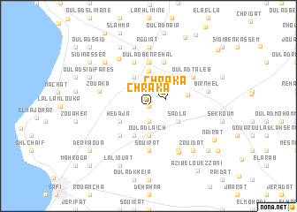
Chraka (Safi, Morocco)Chraka is a town in the Safi region of Morocco. An overview map of the region around Chraka is displayed below.
regional and 3d topo map of Chraka, Morocco ::
Chraka airports ::
The nearest airport is RAK - Marrakech Menara, located 135.9 km south east of Chraka.
Other airports nearby include CMN - Casablanca Mohammed V Intl (179.9 km north east), Nearby towns ::
Oulad Brahim (0.0km north) //
Sidi Layachi (1.9km south) //
Chraka (2.0km north east) //
Bounifel (3.7km south) //
Oulad Laïch (3.7km south) //
Lahmamna (3.7km south) //
Jmara (4.0km south west) //
Sâdla (3.6km south east) //
Moualda (4.0km north west) //
Draouch (3.6km south west) //
Hedaja (3.6km south west) //
El Had Harrara (4.4km north) //
Chleuh (4.4km east) //
Jelidat (4.9km north east) //
Lâjema (4.9km north east) //
Karouch (4.9km south west) //
El Grinat (5.6km south) //
Souirat (5.6km south) //
Oulad Ben Rehal (5.6km north) //
Oulad Ben Jelloul (5.8km north) //
Bouilhat (5.8km north) //
Zouaka (5.6km west) //
Khelalfa (6.4km south east) //
Oulad Taleb (6.0km north east) //
Oulad Mbarek (6.6km south east) //
El Hamadat (6.9km north west) //
Rguiat (7.4km north) //
Bir Nhel (6.5km east) //
El Braouda (7.6km north) //
[all distances 'as the bird flies' and approximate]  Places with similar names to Chraka, Morocco ::
Disclaimer :: Information on this page comes without warranty of any kind |
||
|
Where is Chraka? Elevation and coordinates ::
Latitude (lat): 32°24'0"N Longitude (lon): 9°8'0"W
Elevation (approx.): 102m (map arrows pan, magnifying glasses zoom) |
||
|
Visiting Chraka? Hotel/Accommodation ::
Book a hotel in Chraka Travel Guide ::
Buy a travel guide for Morocco rental cars ::
car rental offers GPS waypoint ::
download a GPX waypoint (PoI) of Chraka for your GPS receiver
|
||