|
search place name
|
||
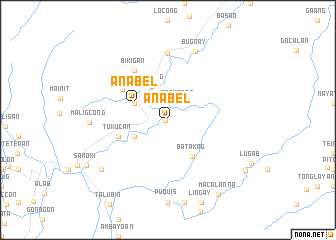
Anabel (Mountain, Philippines)Anabel is a town in the Mountain region of Philippines. An overview map of the region around Anabel is displayed below.
regional and 3d topo map of Anabel, Philippines ::
Anabel airports ::
The nearest airport is BAG - Baguio, located 96.5 km south west of Anabel.
Nearby towns ::
Mamabui (0.3km west) //
Betwagan (2.2km north east) //
Gawa (4.0km south west) //
Baguang (4.1km north west) //
Saclit (4.0km north west) //
Anabel (4.0km north west) //
Batakag (4.9km south east) //
Tukucan (5.6km west) //
Chenglis (5.6km west) //
Sacasacan (5.9km north west) //
Sadanga (6.2km north west) //
Baliwang (6.6km north west) //
Bikigan (6.6km north west) //
Belwang (7.4km north) //
Bugnay (8.2km north) //
Maligcong (8.4km west) //
Caneo (9.0km south west) //
Macalanna (10.0km south east) //
Lias (10.1km south east) //
[all distances 'as the bird flies' and approximate] 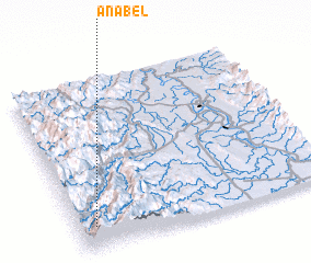 Places with similar names to Anabel, Philippines ::
Disclaimer :: Information on this page comes without warranty of any kind |
||
|
Where is Anabel? Elevation and coordinates ::
Latitude (lat): 17°8'0"N Longitude (lon): 121°4'0"E
Elevation (approx.): 867m (map arrows pan, magnifying glasses zoom) |
||
|
Visiting Anabel? Hotel/Accommodation ::
Book a hotel in Anabel Travel Guide ::
Buy a travel guide for Philippines rental cars ::
car rental offers GPS waypoint ::
download a GPX waypoint (PoI) of Anabel for your GPS receiver
|
||