|
search place name
|
||
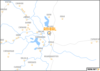
Anibal (Zambézia, Mozambique)Anibal is a town in the Zambézia region of Mozambique. An overview map of the region around Anibal is displayed below.
regional and 3d topo map of Anibal, Mozambique ::
Anibal airports ::
The nearest airport is UEL - Quelimane, located 171.6 km east of Anibal.
Other airports nearby include BLZ - Blantyre Chileka Intl (187.7 km north), TET - Tete Chingodzi (227.3 km north west), Nearby towns ::
Alves (2.6km north) //
Pinda (3.4km south) //
Dêcha (3.4km west) //
Mariçane (3.5km south west) //
Condoeira (3.8km south west) //
Navalha (4.2km south west) //
Botão (4.8km west) //
Supia (6.7km south west) //
Gera (7.0km north) //
Roda (7.7km north east) //
Catunda (7.8km west) //
Ganunga (8.4km west) //
Güéra (8.4km west) //
Águas Quentes (8.9km south) //
Sardinha (8.7km west) //
Dumba (8.8km north west) //
Joaqui (10.3km north west) //
Angorele (10.3km north west) //
[all distances 'as the bird flies' and approximate] 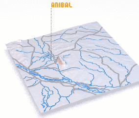 Places with similar names to Anibal, Mozambique ::
Disclaimer :: Information on this page comes without warranty of any kind |
||
|
Where is Anibal? Elevation and coordinates ::
Latitude (lat): 17°20'12"S Longitude (lon): 35°20'44"E
Elevation (approx.): 39m (map arrows pan, magnifying glasses zoom) |
||
|
Visiting Anibal? Hotel/Accommodation ::
Book a hotel in Anibal Travel Guide ::
Buy a travel guide for Mozambique rental cars ::
car rental offers GPS waypoint ::
download a GPX waypoint (PoI) of Anibal for your GPS receiver
|
||