|
search place name
|
||
Baguiangan (Lanao del Sur, Philippines)Baguiangan is a town in the Lanao del Sur region of Philippines. An overview map of the region around Baguiangan is displayed below.
regional and 3d topo map of Baguiangan, Philippines ::

Baguiangan airports ::
The nearest airport is CEB - Cebu Cotabato, located 64.0 km south of Baguiangan.
Other airports nearby include LGP - Legazpi Pagadian (71.5 km west), CGY - Ladag Cagayan De Oro (94.2 km north east), DGT - Dumaguete (197.7 km north west), Nearby towns ::
Calanogas (1.9km north) //
Tatarikan (2.2km west) //
Inoma (2.6km south west) //
Tangcal (3.7km east) //
Dapao (4.1km north west) //
Tatarikan (5.2km north east) //
Robucon (6.7km south) //
Danugan (7.1km north west) //
Gadungan (7.6km north) //
Linindingan (7.6km north) //
Gui (7.6km north) //
Sultaruro (7.6km east) //
Tabuan (7.6km north) //
Kalalanuan (7.6km north) //
Budas (7.6km north) //
Taliugun (7.6km north) //
Kalilidan (8.3km north east) //
Lumbak (8.3km north east) //
Macaguiling (8.3km north east) //
Pinalangca (8.3km north east) //
Maligo (8.2km north west) //
Tubaran (8.2km north east) //
Marogong (9.2km south east) //
Gas (9.2km south west) //
Lumbak (9.2km north east) //
Notong (9.2km north west) //
Balut-Maito (9.2km north east) //
Kialilidan (9.2km north east) //
Basak (9.2km north east) //
[all distances 'as the bird flies' and approximate] 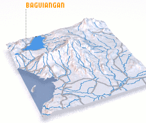 Places with similar names to Baguiangan, Philippines ::
// Bacangan (PH)
// Bacuñgan (PH)
// Bacungan (PH)
// Boca Engaño (PH)
// Bākān-e Kahn (IR)
// Begungaon (BD)
// Bégangon (BJ)
// Bakongan (ID)
// Bekancan (ID)
Disclaimer :: Information on this page comes without warranty of any kind |
||
|
Where is Baguiangan? Elevation and coordinates ::
Latitude (lat): 7°44'0"N Longitude (lon): 124°6'0"E
Elevation (approx.): 619m (map arrows pan, magnifying glasses zoom) |
||
|
Visiting Baguiangan? Hotel/Accommodation ::
Book a hotel in Baguiangan Travel Guide ::
Buy a travel guide for Philippines rental cars ::
car rental offers GPS waypoint ::
download a GPX waypoint (PoI) of Baguiangan for your GPS receiver
|
||