|
search place name
|
||
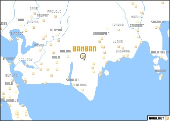
Bamban (Mindoro Occidental, Philippines)Bamban is a town in the Mindoro Occidental region of Philippines. An overview map of the region around Bamban is displayed below.
regional and 3d topo map of Bamban, Philippines ::
Bamban airports ::
The nearest airport is KLO - Kalibo, located 141.6 km south east of Bamban.
Other airports nearby include SJI - San Jose Antique (185.0 km south east), ILO - Iloilo (225.6 km south east), BCD - Bacolod (259.7 km south east), Nearby towns ::
Paglinaoan (2.0km east) //
Binaliw (2.3km south east) //
Binaliw (3.1km south east) //
Malingin (3.8km west) //
Burinawan (4.1km east) //
Alimawan (4.2km south east) //
Cara (4.5km east) //
Bating (4.7km south east) //
Guiob (4.7km east) //
Cabugao (4.8km north east) //
Lidong (4.8km north east) //
Quibongan (5.0km north east) //
Dayangdang (5.2km north east) //
Sibalat (5.9km south west) //
Manhapon (6.1km north east) //
Bolo (6.0km west) //
Parayparay (6.4km west) //
Alibug (6.6km south) //
Bayombang (7.0km west) //
Gamut (7.3km north west) //
Mauhao (7.3km east) //
Llama (7.9km north east) //
Sibalat (7.9km south west) //
Otoyan (8.2km north west) //
Lumlum (8.2km north west) //
Batirawan (8.2km west) //
Bolangoan (8.5km north east) //
Buswang (8.4km east) //
Laonag (8.5km east) //
[all distances 'as the bird flies' and approximate] 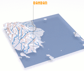 Places with similar names to Bamban, Philippines ::
Disclaimer :: Information on this page comes without warranty of any kind |
||
|
Where is Bamban? Elevation and coordinates ::
Latitude (lat): 12°17'22"N Longitude (lon): 121°13'58"E
Elevation (approx.): 239m (map arrows pan, magnifying glasses zoom) |
||
|
Visiting Bamban? Hotel/Accommodation ::
Book a hotel in Bamban Travel Guide ::
Buy a travel guide for Philippines rental cars ::
car rental offers GPS waypoint ::
download a GPX waypoint (PoI) of Bamban for your GPS receiver
|
||