|
search place name
|
||
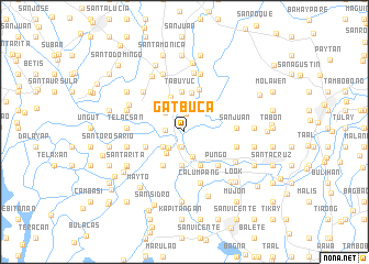
Gatbuca (Bulacan, Philippines)Gatbuca is a town in the Bulacan region of Philippines. An overview map of the region around Gatbuca is displayed below.
regional and 3d topo map of Gatbuca, Philippines ::
Gatbuca airports ::
The nearest airport is MNL - Manila Ninoy Aquino Intl, located 53.9 km south east of Gatbuca.
Other airports nearby include BAG - Baguio (160.7 km north), Nearby towns ::
Sucol (1.5km south) //
Balete (1.5km south) //
Iba Oeste (1.5km south) //
Iba Este (1.5km south) //
Palimbang (1.5km south) //
Corazon (1.5km south) //
Buguion (1.5km south) //
Loñgos (1.5km south) //
Balungao (1.5km south) //
San Jose (1.5km south) //
Pandukot (1.5km south) //
Sapang Bayan (1.5km south) //
Frances (1.5km south) //
Pungo (1.5km south) //
Calumpit (1.6km south) //
San Juan (1.9km north) //
Sulipan (1.9km west) //
Capolangan (2.2km south west) //
Apalit (2.6km north) //
San Miguel (2.6km south west) //
Bagtiag (2.6km south) //
San Vicente (2.7km north west) //
Calizon (2.8km south west) //
Caniugan (3.4km south) //
San Marcos (3.7km south east) //
Balite (3.7km south east) //
San Antonio (3.7km south east) //
San Roque (3.8km north) //
Meysulao (3.9km south west) //
[all distances 'as the bird flies' and approximate]  Places with similar names to Gatbuca, Philippines ::
Disclaimer :: Information on this page comes without warranty of any kind |
||
|
Where is Gatbuca? Elevation and coordinates ::
Latitude (lat): 14°55'49"N Longitude (lon): 120°46'9"E
Elevation (approx.): 8m (map arrows pan, magnifying glasses zoom) |
||
|
Visiting Gatbuca? Hotel/Accommodation ::
Book a hotel in Gatbuca Travel Guide ::
Buy a travel guide for Philippines rental cars ::
car rental offers GPS waypoint ::
download a GPX waypoint (PoI) of Gatbuca for your GPS receiver
|
||