|
search place name
|
||
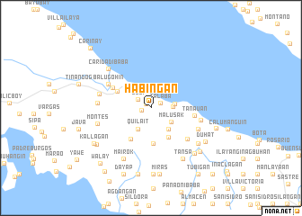
Habingan (Quezon, Philippines)Habingan is a town in the Quezon region of Philippines. An overview map of the region around Habingan is displayed below.
regional and 3d topo map of Habingan, Philippines ::
Habingan airports ::
The nearest airport is MNL - Manila Ninoy Aquino Intl, located 116.3 km north west of Habingan.
Nearby towns ::
Balubad (0.8km north west) //
Kaniat (1.1km west) //
Talaba (1.3km north east) //
Lubi (1.9km north west) //
Buhañgin (2.7km east) //
Lumutan (2.9km east) //
Quilait (3.0km south west) //
Malusak (3.0km south east) //
Lakip (3.3km south east) //
Ponon (4.2km south east) //
San Jose Balatok (4.5km south) //
Mangalayan (4.6km south west) //
Tagbakin (4.5km north west) //
Atimonan (5.2km north west) //
Tanauan (5.3km east) //
San Rafael (5.8km south east) //
Balugohin (5.9km north west) //
Caridad Ilaya (5.9km north west) //
Kulawit (6.2km south east) //
Concepcion (6.2km east) //
San Isidro (6.5km west) //
Sapaan (6.5km west) //
Montes (6.7km west) //
Caridad Ibaba (7.0km north west) //
Mairok (7.1km south west) //
Ilusong (7.2km south east) //
Rizal (7.4km south east) //
Tansa (7.4km south east) //
Socorro (7.8km south east) //
[all distances 'as the bird flies' and approximate] 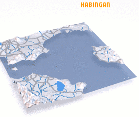 Places with similar names to Habingan, Philippines ::
// Habiñgan (PH)
// Hiabangan (PH)
// Hobangan (PH)
// Hubangon (PH)
// Habangan (BW)
// Habong-ni (KP)
// Habung-ni (KP)
// Haebang-ni (KP)
// Hoebong-ni (KP)
// Hoebong-ni (KP)
Disclaimer :: Information on this page comes without warranty of any kind |
||
|
Where is Habingan? Elevation and coordinates ::
Latitude (lat): 13°58'24"N Longitude (lon): 121°56'51"E
Elevation (approx.): 23m (map arrows pan, magnifying glasses zoom) |
||
|
Visiting Habingan? Hotel/Accommodation ::
Book a hotel in Habingan Travel Guide ::
Buy a travel guide for Philippines rental cars ::
car rental offers GPS waypoint ::
download a GPX waypoint (PoI) of Habingan for your GPS receiver
|
||