|
search place name
|
||
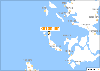
Katagman (Surigao del Norte, Philippines)Katagman is a town in the Surigao del Norte region of Philippines. An overview map of the region around Katagman is displayed below.
regional and 3d topo map of Katagman, Philippines ::
Katagman airports ::
The nearest airport is TAC - Tacloban Daniel Z Romualdez, located 154.6 km north of Katagman.
Other airports nearby include NOP - Masbate Mactan Cebu Intl (173.9 km west), CGY - Ladag Cagayan De Oro (193.6 km south west), Nearby towns ::
Danaon (1.8km west) //
Hikdop (2.0km south) //
Libuao (2.9km south) //
Alegria (3.8km south east) //
Buenavista (5.6km south) //
Zaragoza (6.3km east) //
Buenavista (6.7km south east) //
Tagbayakao (9.2km north east) //
Dinagat (9.5km north east) //
Hanigad (10.1km south east) //
Kantiasay (11.0km south east) //
[all distances 'as the bird flies' and approximate] 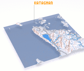 Places with similar names to Katagman, Philippines ::
// Kataguman (PH)
// Kadukkaimunai (LK)
// Kudagammana (LK)
// Kudagammana (LK)
// Gad Gomène (SN)
// Kot Kamboh Nau (PK)
// Kot Kuman (PK)
// Kot Kumān (PK)
// Kouadiokomèné (CI)
Disclaimer :: Information on this page comes without warranty of any kind |
||
|
Where is Katagman? Elevation and coordinates ::
Latitude (lat): 9°55'0"N Longitude (lon): 125°31'0"E
Elevation (approx.): -32768m (map arrows pan, magnifying glasses zoom) |
||
|
Visiting Katagman? Hotel/Accommodation ::
Book a hotel in Katagman Travel Guide ::
Buy a travel guide for Philippines rental cars ::
car rental offers GPS waypoint ::
download a GPX waypoint (PoI) of Katagman for your GPS receiver
|
||