|
search place name
|
||
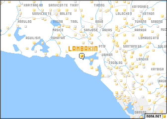
Lambakin (Bulacan, Philippines)Lambakin is a town in the Bulacan region of Philippines. An overview map of the region around Lambakin is displayed below.
regional and 3d topo map of Lambakin, Philippines ::
Lambakin airports ::
The nearest airport is MNL - Manila Ninoy Aquino Intl, located 31.4 km south east of Lambakin.
Other airports nearby include BAG - Baguio (181.8 km north), Nearby towns ::
Bunutan (1.8km east) //
Pariahan (2.6km south east) //
Santa Ines (3.1km north east) //
Bagumbayan (3.7km north) //
Baluarte (3.6km south east) //
Taliptip (3.9km north east) //
Bambang (4.1km north east) //
Babatnin (4.0km north west) //
Santa Ana (4.2km north east) //
Bulacan (4.9km north) //
San Juan (5.4km east) //
Apugan (5.4km east) //
Ubihan (5.4km east) //
Tawiran (5.4km east) //
Tibig (5.6km north) //
Maysantol (5.6km north) //
Balubad (5.6km north) //
San Nicolas (5.6km north) //
Binuañgan (5.5km south east) //
San Jose (5.8km north) //
Paliwas (5.8km north) //
Hulo (5.7km east) //
Bangkal (5.8km north) //
Matungao (6.0km north) //
Pamarauan (5.9km west) //
Pitpitan (6.3km north) //
Paco (6.3km east) //
Namayan (6.5km north west) //
Lawa (6.5km south east) //
[all distances 'as the bird flies' and approximate]  Places with similar names to Lambakin, Philippines ::
Disclaimer :: Information on this page comes without warranty of any kind |
||
|
Where is Lambakin? Elevation and coordinates ::
Latitude (lat): 14°45'0"N Longitude (lon): 120°52'0"E
Elevation (approx.): 5m (map arrows pan, magnifying glasses zoom) |
||
|
Visiting Lambakin? Hotel/Accommodation ::
Book a hotel in Lambakin Travel Guide ::
Buy a travel guide for Philippines rental cars ::
car rental offers GPS waypoint ::
download a GPX waypoint (PoI) of Lambakin for your GPS receiver
|
||