|
search place name
|
||
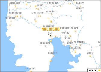
Malingao (Zambales, Philippines)Malingao is a town in the Zambales region of Philippines. An overview map of the region around Malingao is displayed below.
regional and 3d topo map of Malingao, Philippines ::
Malingao airports ::
The nearest airport is MNL - Manila Ninoy Aquino Intl, located 97.5 km south east of Malingao.
Other airports nearby include BAG - Baguio (171.1 km north), Nearby towns ::
Cabitaugan (0.0km north) //
Cawag (1.1km south east) //
Cawag (1.9km south) //
Cabangan (1.8km east) //
Asinan (1.8km east) //
Namapagan (2.6km north) //
Balaybay (2.7km north) //
Manganbaca (3.6km east) //
Subic (3.6km east) //
Mahumiling (4.1km south west) //
Calapandayan (4.1km east) //
Aniñguay (4.6km north east) //
Calapacuan (5.0km south east) //
Castillejos (5.2km north) //
Pamatawan (5.2km north east) //
Santa Maria (5.4km north) //
Tamayoc (5.4km east) //
Nangsolo (5.4km east) //
Tondo (5.6km north) //
Nibañgon (5.7km east) //
Matain (5.9km south east) //
Talugtog (6.5km north) //
Matain (6.5km east) //
Naugsol (6.9km east) //
Samatan (7.2km east) //
Agusuhin (7.5km south) //
Binaritan (7.5km east) //
San Agustin (7.7km north west) //
Nagbuñga (7.9km north) //
[all distances 'as the bird flies' and approximate] 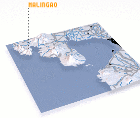 Places with similar names to Malingao, Philippines ::
Disclaimer :: Information on this page comes without warranty of any kind |
||
|
Where is Malingao? Elevation and coordinates ::
Latitude (lat): 14°53'0"N Longitude (lon): 120°12'0"E
Elevation (approx.): 99m (map arrows pan, magnifying glasses zoom) |
||
|
Visiting Malingao? Hotel/Accommodation ::
Book a hotel in Malingao Travel Guide ::
Buy a travel guide for Philippines rental cars ::
car rental offers GPS waypoint ::
download a GPX waypoint (PoI) of Malingao for your GPS receiver
|
||