|
search place name
|
||
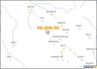
Polonoling (South Cotabato, Philippines)Polonoling is a town in the South Cotabato region of Philippines. An overview map of the region around Polonoling is displayed below.
regional and 3d topo map of Polonoling, Philippines ::
Polonoling airports ::
The nearest airport is CEB - Cebu Cotabato, located 128.3 km north west of Polonoling.
Other airports nearby include LGP - Legazpi Pagadian (238.4 km north west), Nearby towns ::
Basak Pagalongan (2.0km south) //
Koronadal (4.4km south east) //
Crossing Palkan (5.1km south east) //
Tupi (5.8km north west) //
Kabalen (6.1km north east) //
Palkan (7.0km east) //
Belomala (7.9km north) //
Sulit (7.9km south east) //
Buntong (8.3km south east) //
Lumakil (9.3km south east) //
Pagalungan (10.1km south east) //
Lunen (11.1km north west) //
[all distances 'as the bird flies' and approximate] 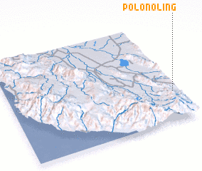 Places with similar names to Polonoling, Philippines ::
// Plei Neh Làng (VN)
Disclaimer :: Information on this page comes without warranty of any kind |
||
|
Where is Polonoling? Elevation and coordinates ::
Latitude (lat): 6°17'17"N Longitude (lon): 124°58'8"E
Elevation (approx.): 384m (map arrows pan, magnifying glasses zoom) |
||
|
Visiting Polonoling? Hotel/Accommodation ::
Book a hotel in Polonoling Travel Guide ::
Buy a travel guide for Philippines rental cars ::
car rental offers GPS waypoint ::
download a GPX waypoint (PoI) of Polonoling for your GPS receiver
|
||