|
search place name
|
||
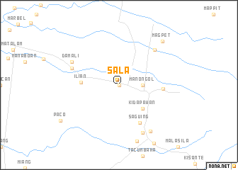
Sala (North Cotabato, Philippines)Sala is a town in the North Cotabato region of Philippines. An overview map of the region around Sala is displayed below.
regional and 3d topo map of Sala, Philippines ::
Sala airports ::
The nearest airport is CEB - Cebu Cotabato, located 94.0 km west of Sala.
Other airports nearby include CGY - Ladag Cagayan De Oro (160.4 km north), LGP - Legazpi Pagadian (196.4 km north west), Nearby towns ::
Tumbaga (0.0km north) //
Balindog (0.0km north) //
Batasan (0.0km north) //
Boracanon (0.0km north) //
Kanapolo (0.0km north) //
Laisan (0.0km north) //
Lamitan (0.0km north) //
Lika (0.0km north) //
Limacon (0.0km north) //
Mamuti (0.0km north) //
Matig-Nuling (0.0km north) //
Kalasuyan (0.0km north) //
Lanao (0.0km north) //
Milakeg (0.0km north) //
Nuangan (0.0km north) //
Hinatilan (0.0km north) //
Manongol (3.7km east) //
Kidapawan (5.2km south east) //
Ilian (6.0km west) //
Saguing (6.7km south east) //
Muaan (6.9km east) //
Marbel (7.8km north east) //
Amas (7.8km west) //
Sibawan (8.3km south east) //
Damali (8.2km north west) //
Indangan (8.7km south east) //
San Vincente (9.2km south) //
Magpet (9.7km north east) //
[all distances 'as the bird flies' and approximate] 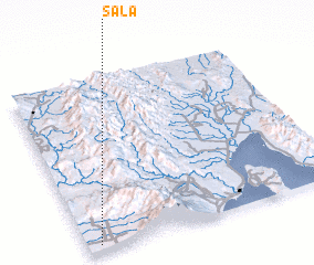 Places with similar names to Sala, Philippines ::
Disclaimer :: Information on this page comes without warranty of any kind |
||
|
Where is Sala? Elevation and coordinates ::
Latitude (lat): 7°2'0"N Longitude (lon): 125°3'0"E
Elevation (approx.): 164m (map arrows pan, magnifying glasses zoom) |
||
|
Visiting Sala? Hotel/Accommodation ::
Book a hotel in Sala Travel Guide ::
Buy a travel guide for Philippines rental cars ::
car rental offers GPS waypoint ::
download a GPX waypoint (PoI) of Sala for your GPS receiver
|
||