|
search place name
|
||
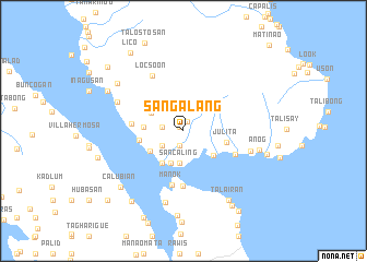
San Galang (Leyte, Philippines)San Galang is a town in the Leyte region of Philippines. An overview map of the region around San Galang is displayed below.
regional and 3d topo map of San Galang, Philippines ::
San Galang airports ::
The nearest airport is TAC - Tacloban Daniel Z Romualdez, located 66.2 km south east of San Galang.
Other airports nearby include NOP - Masbate Mactan Cebu Intl (142.7 km south west), BCD - Bacolod (194.6 km south west), ILO - Iloilo (229.1 km west), Nearby towns ::
Moog (0.5km north west) //
Hugpa (1.1km north) //
Tigbao (1.5km south) //
Pinangomhan (2.2km west) //
Bulalakao (2.6km south west) //
Dalupingan (2.6km south west) //
Sancaling (3.4km south) //
Biliran (3.5km south) //
Cabungaan (3.7km north west) //
Burabod (3.9km south west) //
Beniay (4.0km south west) //
Mambahayan (4.0km south west) //
Balaguid (4.0km south east) //
Bato (4.0km west) //
Julita (4.4km east) //
Busali (4.5km west) //
Mocalbocal (5.3km west) //
Culasi (5.7km south) //
Manok (5.7km south) //
Balagui (5.7km south east) //
Locsoon (6.4km north west) //
Ariquen (7.0km east) //
Catmon (7.3km north west) //
Bontogon (7.5km south) //
Anog (7.9km east) //
Campoding (8.1km north west) //
Talairan (8.4km south east) //
Calubian (8.5km south west) //
Santo Niño (8.6km south) //
[all distances 'as the bird flies' and approximate] 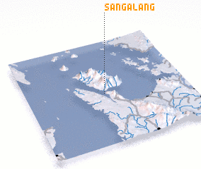 Places with similar names to San Galang, Philippines ::
// Sainglaing (MM)
// Sanglang (MM)
// Senglung (MM)
// Songlong (MM)
// Sanglang (MY)
// Zawngling (IN)
// Sencalang (ID)
// Sankalang (GM)
// Xinglong (CN)
// Xinglong'ao (CN)
Disclaimer :: Information on this page comes without warranty of any kind |
||
|
Where is San Galang? Elevation and coordinates ::
Latitude (lat): 11°29'48"N Longitude (lon): 124°29'11"E
Elevation (approx.): 85m (map arrows pan, magnifying glasses zoom) |
||
|
Visiting San Galang? Hotel/Accommodation ::
Book a hotel in San Galang Travel Guide ::
Buy a travel guide for Philippines rental cars ::
car rental offers GPS waypoint ::
download a GPX waypoint (PoI) of San Galang for your GPS receiver
|
||