|
search place name
|
||
San Juan (Camarines Sur, Philippines)San Juan is a town in the Camarines Sur region of Philippines. An overview map of the region around San Juan is displayed below.
regional and 3d topo map of San Juan, Philippines ::

San Juan airports ::
The nearest airport is KLO - Kalibo, located 231.2 km south of San Juan.
Nearby towns ::
Malansad (1.4km west) //
San Vicente (1.5km south east) //
Bugnad (1.7km north) //
Aba (2.0km north west) //
Mambulo Viejo (2.4km south west) //
Malbogon (2.8km north) //
San Nicolas (2.8km east) //
Barobaybay (3.1km north east) //
Cagbugna (3.5km south east) //
San Pablo (3.7km west) //
Cagbibi (3.7km south east) //
Concepcion (3.9km north) //
Plancha (4.0km north west) //
Contod (4.1km south) //
Cuyapi (4.2km north east) //
San Francisco (4.1km east) //
Liniaga (4.1km east) //
Fundado (4.4km east) //
Patong (4.6km south east) //
Polot (4.6km north west) //
Batang (4.9km south east) //
Hinornohan (4.9km west) //
Duangniog (5.0km west) //
Libmanan (5.3km north west) //
Patag (5.3km north) //
Ponong (5.3km north east) //
Handong (5.5km north) //
Labao (5.5km north) //
Del Carmen (5.5km north) //
[all distances 'as the bird flies' and approximate] 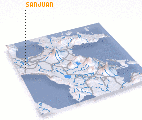 Places with similar names to San Juan, Philippines ::
Disclaimer :: Information on this page comes without warranty of any kind |
||
|
Where is San Juan? Elevation and coordinates ::
Latitude (lat): 13°39'8"N Longitude (lon): 123°4'42"E
Elevation (approx.): 2m (map arrows pan, magnifying glasses zoom) |
||
|
Visiting San Juan? Hotel/Accommodation ::
Book a hotel in San Juan Travel Guide ::
Buy a travel guide for Philippines rental cars ::
car rental offers GPS waypoint ::
download a GPX waypoint (PoI) of San Juan for your GPS receiver
|
||