|
search place name
|
||
Sinipit-bubon (Nueva Ecija, Philippines)Sinipit-bubon is a town in the Nueva Ecija region of Philippines. An overview map of the region around Sinipit-bubon is displayed below.
regional and 3d topo map of Sinipit-bubon, Philippines ::

Sinipit-bubon airports ::
The nearest airport is BAG - Baguio, located 76.9 km north west of Sinipit-bubon.
Other airports nearby include MNL - Manila Ninoy Aquino Intl (139.3 km south), Nearby towns ::
Manacsac (1.8km east) //
Tumana (1.8km east) //
Abar Segundo (1.9km north) //
Caanawan (1.9km north) //
Santo Tomas (2.2km south west) //
Abar Primero (2.3km north) //
Asta (2.6km south west) //
Santo Niño Primero (3.6km north) //
Cabatuan (3.6km east) //
Magtanggol (3.6km west) //
San Jose (3.9km north east) //
Tulat (4.0km north east) //
Sibot (4.0km north east) //
Villafloresta (4.1km north east) //
Trinidad (4.1km north east) //
San Francisco (4.1km north east) //
Florida Blanca (4.1km north east) //
Bagong Bayan (4.1km north east) //
Galilea (4.1km north east) //
San Juan (4.1km north east) //
Saranay (4.1km north east) //
Pinili (4.1km north east) //
Tabulac (4.0km south east) //
Sapang Putat (4.0km north west) //
Sapang Cawayan Segundo (4.1km south west) //
Licaon (4.0km south west) //
Santo Niño Segundo (4.9km north) //
Dizol (4.8km south east) //
Tumana (4.8km east) //
[all distances 'as the bird flies' and approximate] 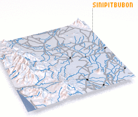 Places with similar names to Sinipit-bubon, Philippines :: Disclaimer :: Information on this page comes without warranty of any kind |
||
|
Where is Sinipit-bubon? Elevation and coordinates ::
Latitude (lat): 15°46'0"N Longitude (lon): 120°58'0"E
Elevation (approx.): 95m (map arrows pan, magnifying glasses zoom) |
||
|
Visiting Sinipit-bubon? Hotel/Accommodation ::
Book a hotel in Sinipit-bubon Travel Guide ::
Buy a travel guide for Philippines rental cars ::
car rental offers GPS waypoint ::
download a GPX waypoint (PoI) of Sinipit-bubon for your GPS receiver
|
||