|
search place name
|
||
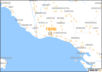
Tapai (Calbayog, Philippines)Tapai is a town in the Calbayog region of Philippines. An overview map of the region around Tapai is displayed below.
regional and 3d topo map of Tapai, Philippines ::
Tapai airports ::
The nearest airport is TAC - Tacloban Daniel Z Romualdez, located 104.7 km south east of Tapai.
Other airports nearby include NOP - Masbate Mactan Cebu Intl (205.5 km south), BCD - Bacolod (239.6 km south west), Nearby towns ::
Tomaliguis (0.0km north) //
Tigbi (0.0km north) //
Rosales (0.0km north) //
Nijaga (0.0km north) //
Quiliquili (0.0km north) //
Naguma (0.0km north) //
Bagacay (0.0km north) //
Limarayon (0.0km north) //
Cacaransan (0.0km north) //
Olera (0.0km north) //
Capo-ocan (0.0km north) //
Pinamorotan (0.0km north) //
Palañugan (0.0km north) //
Caballero (0.0km north) //
Enora (0.0km north) //
Gabay (0.0km north) //
Gasdo (0.0km north) //
Cagtotolo (0.0km north) //
Guinbaoyan Norte (0.0km north) //
Guinbaoyan Sur (0.0km north) //
Guin-on (0.0km north) //
Cagbanayacao (0.0km north) //
Himalanrog (0.0km north) //
Himaotan (0.0km north) //
Hiraga-an (0.0km north) //
Cagboborac (0.0km north) //
Osmeña (0.0km north) //
Adgao (0.0km north) //
Cogon (0.0km north) //
[all distances 'as the bird flies' and approximate]  Places with similar names to Tapai, Philippines ::
Disclaimer :: Information on this page comes without warranty of any kind |
||
|
Where is Tapai? Elevation and coordinates ::
Latitude (lat): 12°4'0"N Longitude (lon): 124°35'0"E
Elevation (approx.): 3m (map arrows pan, magnifying glasses zoom) |
||
|
Visiting Tapai? Hotel/Accommodation ::
Book a hotel in Tapai Travel Guide ::
Buy a travel guide for Philippines rental cars ::
car rental offers GPS waypoint ::
download a GPX waypoint (PoI) of Tapai for your GPS receiver
|
||