|
search place name
|
||
Veronica (Ilocos Norte, Philippines)Veronica is a town in the Ilocos Norte region of Philippines. An overview map of the region around Veronica is displayed below.
regional and 3d topo map of Veronica, Philippines ::

Veronica airports ::
The nearest airport is BAG - Baguio, located 187.2 km south of Veronica.
Nearby towns ::
Busel (1.3km south west) //
San Pedro (1.9km south) //
San Mateo (1.9km south) //
Al-lalabang (1.9km west) //
Camandigan (2.5km east) //
Capac-cuan (2.8km south) //
Nagbacalan (3.7km north) //
Dariwdiw (3.7km north) //
Sumgar (3.7km south) //
Baligat (4.0km north west) //
San Pedro (4.0km north east) //
Biningan (4.0km south west) //
Batac (4.1km south west) //
Bil-loca (4.4km north west) //
Bungon (4.5km north) //
Santo Santiago (5.0km north east) //
Sumader (5.1km south west) //
Anangui (5.1km north west) //
Tangdan (5.1km north east) //
San Bernabe (5.1km north east) //
Santa Rosa (5.1km north east) //
Allangigan (5.1km south west) //
Cabaruan (5.1km south west) //
Daparyden (5.3km east) //
Barbarangay (5.8km south) //
Quiling (5.9km west) //
Payao (6.2km south west) //
Baay (6.6km north) //
Pariir (6.6km north east) //
[all distances 'as the bird flies' and approximate] 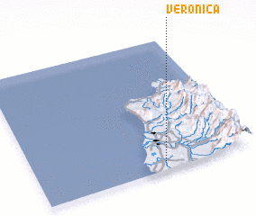 Places with similar names to Veronica, Philippines ::
Disclaimer :: Information on this page comes without warranty of any kind |
||
|
Where is Veronica? Elevation and coordinates ::
Latitude (lat): 18°4'0"N Longitude (lon): 120°36'0"E
Elevation (approx.): 30m (map arrows pan, magnifying glasses zoom) |
||
|
Visiting Veronica? Hotel/Accommodation ::
Book a hotel in Veronica Travel Guide ::
Buy a travel guide for Philippines rental cars ::
car rental offers GPS waypoint ::
download a GPX waypoint (PoI) of Veronica for your GPS receiver
|
||