|
search place name
|
||
Chinghtawng (Kachin State, Myanmar)Chinghtawng is a town in the Kachin State region of Myanmar. An overview map of the region around Chinghtawng is displayed below.
regional and 3d topo map of Chinghtawng, Myanmar ::

Chinghtawng airports ::
The nearest airport is MYT - Myitkyina, located 68.8 km south west of Chinghtawng.
Other airports nearby include PBU - Putao (161.4 km north), Nearby towns ::
Mara (3.7km south) //
Manonkadit (3.3km east) //
Khajankawng (3.8km south east) //
Kahtangbum (5.0km north west) //
Tumpangka (5.0km west) //
Lephtawng (5.3km west) //
Tunpauyang (6.2km north east) //
Pauri (6.5km north east) //
Lakawng (6.5km north east) //
Malayang (6.9km west) //
Ningpyen (7.5km south east) //
Labangkawng (7.5km south west) //
Ningrangkawng (8.7km north west) //
Atankawng (8.9km south east) //
Pungka (10.0km north east) //
[all distances 'as the bird flies' and approximate] 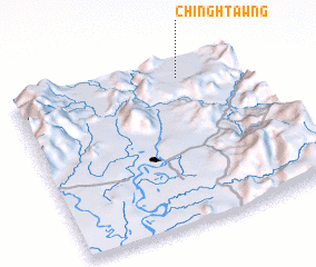 Places with similar names to Chinghtawng, Myanmar ::
// Shandaung (MM)
// Shantaung (MM)
// Shantaungu (MM)
// Shanting (MM)
// Sheing Htang (MM)
// Chuntang (IN)
// Chantung (GH)
// Chandanke (PK)
// Chain-dong (KP)
// Ch'angho-dong (KP)
Disclaimer :: Information on this page comes without warranty of any kind |
||
|
Where is Chinghtawng? Elevation and coordinates ::
Latitude (lat): 25°54'0"N Longitude (lon): 97°44'0"E
Elevation (approx.): 698m (map arrows pan, magnifying glasses zoom) |
||
|
Visiting Chinghtawng? Hotel/Accommodation ::
Book a hotel in Chinghtawng Travel Guide ::
Buy a travel guide for Myanmar rental cars ::
car rental offers GPS waypoint ::
download a GPX waypoint (PoI) of Chinghtawng for your GPS receiver
|
||