|
search place name
|
||
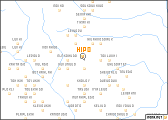
Hipo (Kayin, Myanmar)Hipo is a town in the Kayin region of Myanmar. An overview map of the region around Hipo is displayed below.
regional and 3d topo map of Hipo, Myanmar ::
Hipo airports ::
The nearest airport is RGN - Yangon Intl, located 220.2 km south west of Hipo.
Nearby towns ::
Suklo (1.9km south) //
Pawkhi (3.5km east) //
Plekomudo (3.5km west) //
Kekumudo (4.0km south west) //
Hidawkodo Atet (4.1km north east) //
Hidawkawdo (4.1km north west) //
Hidawkodo Auk (5.1km north east) //
Kholay (5.6km south) //
Taklukhi (5.3km east) //
Taklawkhi Auk (5.3km east) //
Htasude (5.6km west) //
Leiwapu (5.8km north) //
Dwedo Ale (6.4km south east) //
Pawpomudo (6.6km north west) //
Tanyalawdo (6.6km south west) //
Sehpati (6.6km north west) //
Tasudi (7.4km south) //
Tikakhi (7.4km north) //
Dwedo Atet (7.3km east) //
Kokawdo (7.3km west) //
Dwedo Auk (7.7km south east) //
Kyaledo (8.2km south east) //
Dwedo (9.0km south east) //
Ploeywemudö (10.4km south east) //
[all distances 'as the bird flies' and approximate] 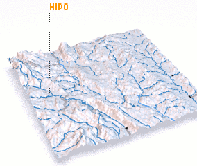 Places with similar names to Hipo, Myanmar ::
Disclaimer :: Information on this page comes without warranty of any kind |
||
|
Where is Hipo? Elevation and coordinates ::
Latitude (lat): 18°38'0"N Longitude (lon): 97°10'0"E
Elevation (approx.): 1197m (map arrows pan, magnifying glasses zoom) |
||
|
Visiting Hipo? Hotel/Accommodation ::
Book a hotel in Hipo Travel Guide ::
Buy a travel guide for Myanmar rental cars ::
car rental offers GPS waypoint ::
download a GPX waypoint (PoI) of Hipo for your GPS receiver
|
||