|
search place name
|
||
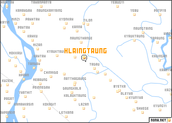
Hlaingtaung (Kayin, Myanmar)Hlaingtaung is a town in the Kayin region of Myanmar. An overview map of the region around Hlaingtaung is displayed below.
regional and 3d topo map of Hlaingtaung, Myanmar ::
Hlaingtaung airports ::
The nearest airport is RGN - Yangon Intl, located 172.8 km west of Hlaingtaung.
Other airports nearby include LPT - Lampang (238.0 km north east), Nearby towns ::
Tada-u (2.3km south east) //
Sanpri (2.5km west) //
Naungpalein (3.3km south east) //
Naungthangè (4.3km north) //
Naungtra (4.8km south east) //
Natthagaung (5.2km south west) //
Sanpannon (5.3km south west) //
Kodri (5.7km south west) //
Kyauktaung (6.2km west) //
Naungtodi (6.5km south east) //
Kanna (6.9km north) //
Daungkala (7.3km south west) //
Naungtok (8.0km south) //
Tilon (8.1km north) //
Chinmido (8.0km south west) //
Tabuto (8.4km north) //
Kalauktaung (8.7km south) //
Mokkadi (8.6km north west) //
Kyonkaw (9.3km north west) //
Mokkare (9.2km south east) //
Byetka (9.4km south east) //
[all distances 'as the bird flies' and approximate]  Places with similar names to Hlaingtaung, Myanmar ::
// Lingatong (PH)
// Liung Tangah (PH)
// Long Tengoa (MY)
// Langting (IN)
// Lengteng (IN)
// Lungding (IN)
// Lingadang (ID)
// Langtang (NG)
// Long Tong (LA)
// Longtawng (MM)
Disclaimer :: Information on this page comes without warranty of any kind |
||
|
Where is Hlaingtaung? Elevation and coordinates ::
Latitude (lat): 16°55'30"N Longitude (lon): 97°45'18"E
Elevation (approx.): 19m (map arrows pan, magnifying glasses zoom) |
||
|
Visiting Hlaingtaung? Hotel/Accommodation ::
Book a hotel in Hlaingtaung Travel Guide ::
Buy a travel guide for Myanmar rental cars ::
car rental offers GPS waypoint ::
download a GPX waypoint (PoI) of Hlaingtaung for your GPS receiver
|
||