|
search place name
|
||
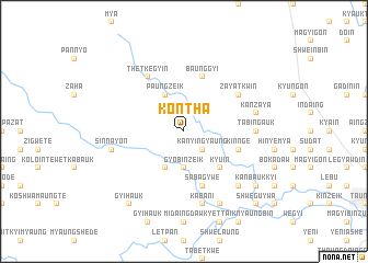
Konthā (Myanmar)Konthā is a town in Myanmar. An overview map of the region around Konthā is displayed below.
regional and 3d topo map of Konthā, Myanmar ::
Konthā airports ::
The nearest airport is HEH - Heho, located 201.1 km north of Konthā.
Other airports nearby include SNW - Thandwe (215.8 km west), Nearby towns ::
Kanyingyaung (2.6km south east) //
Gyobinzeik (3.7km south) //
Paungzeik (4.1km north west) //
Tabulein (4.1km south west) //
Kyu-in (5.1km south east) //
Sabagywe (5.8km south) //
Baunggyi (5.8km north) //
Kinnge (5.6km east) //
Zayatkwin (6.4km north east) //
Thetkegyin (6.6km north west) //
Tabingauk (7.0km east) //
Nebugon (7.2km east) //
Kanzaya (7.2km east) //
Kabani (7.6km south) //
Sinnayon (7.3km west) //
Seikmyaung (7.3km west) //
Mwehauk (7.3km west) //
Pyezo-in (7.7km south east) //
Shanywa (8.2km south east) //
Kanbaukkyi (8.9km south east) //
Gyihauk (9.1km south west) //
Pabewa (10.2km south east) //
Shweguywa (10.2km south east) //
[all distances 'as the bird flies' and approximate] 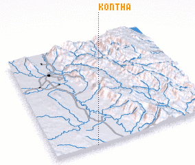 Places with similar names to Konthā, Myanmar ::
Disclaimer :: Information on this page comes without warranty of any kind |
||
|
Where is Konthā? Elevation and coordinates ::
Latitude (lat): 19°0'0"N Longitude (lon): 96°16'0"E
Elevation (approx.): 88m (map arrows pan, magnifying glasses zoom) |
||
|
Visiting Konthā? Hotel/Accommodation ::
Book a hotel in Konthā Travel Guide ::
Buy a travel guide for Myanmar rental cars ::
car rental offers GPS waypoint ::
download a GPX waypoint (PoI) of Konthā for your GPS receiver
|
||