|
search place name
|
||
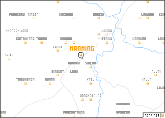
Mān Ming (Kachin State, Myanmar)Mān Ming is a town in the Kachin State region of Myanmar. An overview map of the region around Mān Ming is displayed below.
regional and 3d topo map of Mān Ming, Myanmar ::
Mān Ming airports ::
The nearest airport is MYT - Myitkyina, located 42.1 km west of Mān Ming.
Other airports nearby include PBU - Putao (205.3 km north), Nearby towns ::
Sailaw (2.5km south east) //
Mān Mau (2.5km south west) //
Laisi (4.1km south west) //
Nangchang (4.1km north west) //
Nangma (5.0km north west) //
Lajut (5.3km west) //
Kazu (5.8km south) //
Singkat (6.2km south west) //
Seniku (6.2km north east) //
Loingu (6.5km north east) //
Loingu (7.5km north east) //
Wuman (8.7km south west) //
[all distances 'as the bird flies' and approximate]  Places with similar names to Mān Ming, Myanmar ::
// Manmong (MM)
// Mān Mong (MM)
// Mān Mong (MM)
// Mān Namnōk (MM)
// Monmongou (BJ)
// Manuamang (TP)
// Manamang (PG)
// Manemong (PG)
// Minami-nagae (JP)
// Mbenmong (CM)
Disclaimer :: Information on this page comes without warranty of any kind |
||
|
Where is Mān Ming? Elevation and coordinates ::
Latitude (lat): 25°30'0"N Longitude (lon): 97°45'0"E
Elevation (approx.): 259m (map arrows pan, magnifying glasses zoom) |
||
|
Visiting Mān Ming? Hotel/Accommodation ::
Book a hotel in Mān Ming Travel Guide ::
Buy a travel guide for Myanmar rental cars ::
car rental offers GPS waypoint ::
download a GPX waypoint (PoI) of Mān Ming for your GPS receiver
|
||