|
search place name
|
||
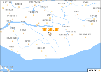
Mingalun (Yangon, Myanmar)Mingalun is a town in the Yangon region of Myanmar. An overview map of the region around Mingalun is displayed below.
regional and 3d topo map of Mingalun, Myanmar ::
Mingalun airports ::
The nearest airport is RGN - Yangon Intl, located 50.5 km north west of Mingalun.
Nearby towns ::
Ase-ywa (2.0km north) //
Kwinbauk (4.9km north) //
Moksozeik (5.0km east) //
Kamakalok (5.8km south west) //
Kanaung (6.2km north east) //
Uyin (6.3km north west) //
Kamalan (6.5km south west) //
Ywathit (6.5km north west) //
Wegyi (6.6km north) //
Kala-ywa (7.5km south) //
Myagaing (7.7km east) //
Kunhni (8.4km west) //
Tamangyi (9.9km north west) //
[all distances 'as the bird flies' and approximate] 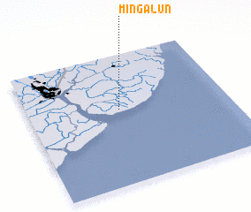 Places with similar names to Mingalun, Myanmar ::
// Mainglon (MM)
// Manglon (MM)
// Mān-kao-lone (MM)
// Mingalun (MM)
// Monglon (MM)
// Möng Lun (MM)
// Mainklein (DE)
// Moncalián (ES)
// Manglón (MX)
// Mainguelane (MZ)
Disclaimer :: Information on this page comes without warranty of any kind |
||
|
Where is Mingalun? Elevation and coordinates ::
Latitude (lat): 16°34'44"N Longitude (lon): 96°27'41"E
Elevation (approx.): 11m (map arrows pan, magnifying glasses zoom) |
||
|
Visiting Mingalun? Hotel/Accommodation ::
Book a hotel in Mingalun Travel Guide ::
Buy a travel guide for Myanmar rental cars ::
car rental offers GPS waypoint ::
download a GPX waypoint (PoI) of Mingalun for your GPS receiver
|
||