|
search place name
|
||
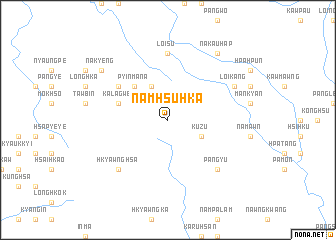
Namhsu-hka (Shan, Myanmar)Namhsu-hka is a town in the Shan region of Myanmar. An overview map of the region around Namhsu-hka is displayed below.
regional and 3d topo map of Namhsu-hka, Myanmar ::
Namhsu-hka airports ::
The nearest airport is MDL - Mandalay Intl, located 107.2 km south west of Namhsu-hka.
Other airports nearby include LSH - Lashio (132.8 km north east), HEH - Heho (195.5 km south), Nearby towns ::
Ku-zu (3.9km south east) //
Nanyok (4.1km north west) //
Pyinmana (5.0km north west) //
Kalagwe (5.5km west) //
Tawmawgôn (6.3km north west) //
Loisu (7.4km north) //
Könghsa (7.4km north) //
Pang-yu (7.6km south east) //
Hkyawnghsa (7.6km south west) //
Loikang (7.8km north east) //
Nakauhap (9.0km north east) //
Nākyeng (8.8km north west) //
[all distances 'as the bird flies' and approximate] 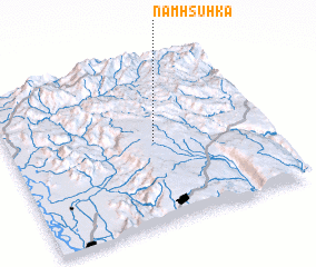 Places with similar names to Namhsu-hka, Myanmar ::
// Namhsawk (MM)
// Namhsai-hkao (MM)
// Namhsuhka (MM)
// Namazgah (AZ)
// Nammawsawk (MM)
// Namsai Hkau (MM)
// Nemeske (HU)
// Namazgâh (TR)
// Namsk (RU)
// Namskiy (RU)
Disclaimer :: Information on this page comes without warranty of any kind |
||
|
Where is Namhsu-hka? Elevation and coordinates ::
Latitude (lat): 22°30'0"N Longitude (lon): 96°34'0"E
Elevation (approx.): 1022m (map arrows pan, magnifying glasses zoom) |
||
|
Visiting Namhsu-hka? Hotel/Accommodation ::
Book a hotel in Namhsu-hka Travel Guide ::
Buy a travel guide for Myanmar rental cars ::
car rental offers GPS waypoint ::
download a GPX waypoint (PoI) of Namhsu-hka for your GPS receiver
|
||