|
search place name
|
||
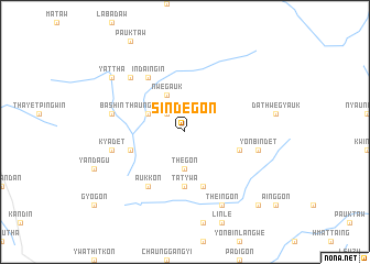
Sindègon (Myanmar)Sindègon is a town in Myanmar. An overview map of the region around Sindègon is displayed below.
regional and 3d topo map of Sindègon, Myanmar ::
Sindègon airports ::
The nearest airport is SNW - Thandwe, located 120.4 km west of Sindègon.
Other airports nearby include RGN - Yangon Intl (210.7 km south), KYP - Kyaukpyu (214.5 km north west), Nearby towns ::
Tegyigon (2.6km north west) //
Thègon (3.7km south) //
Thaungmegyi (4.0km north west) //
Nwegauk (4.1km north west) //
Tatywa (5.6km south) //
Saukchongyi (5.6km west) //
Shwegyogon (5.8km south) //
Sègyigyo (5.6km east) //
Aukkon (6.6km south west) //
Indaing-in (6.6km north west) //
Yonbindet (7.3km east) //
Kyadet (7.3km west) //
Bashin (7.3km west) //
Sinmizwe (7.7km north west) //
Theingon (8.2km south east) //
Yattha (9.0km north west) //
Thanboktaung (10.2km south east) //
[all distances 'as the bird flies' and approximate]  Places with similar names to Sindègon, Myanmar ::
// Sindawgon (MM)
// Sindegon (MM)
// Sindègon (MM)
// Sandakan (MY)
// Sondokan (MY)
// Sondokon (MY)
// Sindikianá (GR)
// San-Di-Gan (US)
// Santaquin (US)
// Sāndikona (BD)
Disclaimer :: Information on this page comes without warranty of any kind |
||
|
Where is Sindègon? Elevation and coordinates ::
Latitude (lat): 18°41'0"N Longitude (lon): 95°25'0"E
Elevation (approx.): 32m (map arrows pan, magnifying glasses zoom) |
||
|
Visiting Sindègon? Hotel/Accommodation ::
Book a hotel in Sindègon Travel Guide ::
Buy a travel guide for Myanmar rental cars ::
car rental offers GPS waypoint ::
download a GPX waypoint (PoI) of Sindègon for your GPS receiver
|
||