|
search place name
|
||
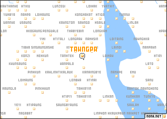
Tawngpa (Shan, Myanmar)Tawngpa is a town in the Shan region of Myanmar. An overview map of the region around Tawngpa is displayed below.
regional and 3d topo map of Tawngpa, Myanmar ::
Tawngpa airports ::
The nearest airport is HEH - Heho, located 77.8 km north of Tawngpa.
Other airports nearby include MDL - Mandalay Intl (205.8 km north west), Nearby towns ::
Longkwe (1.9km south) //
Kawngleng (2.5km north west) //
Kawngmi (2.5km north east) //
Sampyan (3.7km north) //
Tanhtek (3.5km west) //
Longpaw (4.1km north west) //
Ham-en (4.1km south west) //
Kawngmi Ale (4.1km north east) //
Namhsin (4.1km north east) //
Kanaingbye (4.1km south east) //
Tanhtek Myauk (3.9km north west) //
Wān Palo (3.9km south west) //
Möng-u (5.2km east) //
Loi-maw (5.2km east) //
Lenbwa (5.8km south) //
Thabyebin (5.8km north) //
Pinthapyu (5.8km south) //
Htinai (5.8km south) //
Htitali (6.4km north west) //
Kawlin Htikalauk (6.4km south west) //
Longkam (6.6km north east) //
Sawng-o (7.4km north) //
Tahkayin (7.4km south) //
Tadauk (7.6km south) //
Hpa-tek (7.2km east) //
Lai-noi (7.2km east) //
Loi-Taing (7.9km north east) //
Namhpe (7.9km south east) //
Kawngton (8.2km north west) //
[all distances 'as the bird flies' and approximate] 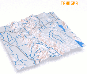 Places with similar names to Tawngpa, Myanmar ::
Disclaimer :: Information on this page comes without warranty of any kind |
||
|
Where is Tawngpa? Elevation and coordinates ::
Latitude (lat): 20°3'0"N Longitude (lon): 96°53'0"E
Elevation (approx.): 1174m (map arrows pan, magnifying glasses zoom) |
||
|
Visiting Tawngpa? Hotel/Accommodation ::
Book a hotel in Tawngpa Travel Guide ::
Buy a travel guide for Myanmar rental cars ::
car rental offers GPS waypoint ::
download a GPX waypoint (PoI) of Tawngpa for your GPS receiver
|
||