|
search place name
|
||
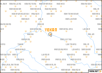
Ye-kan (Shan, Myanmar)Ye-kan is a town in the Shan region of Myanmar. An overview map of the region around Ye-kan is displayed below.
regional and 3d topo map of Ye-kan, Myanmar ::
Ye-kan airports ::
The nearest airport is LSH - Lashio, located 90.7 km north of Ye-kan.
Other airports nearby include MDL - Mandalay Intl (178.6 km west), HEH - Heho (179.8 km south west), MOG - Mong Hsat (248.5 km south east), Nearby towns ::
Lukhpakha (2.5km north east) //
Nā-la (3.9km north west) //
Ho-hko (5.1km north west) //
Hio-hsawng (5.5km west) //
Mān Hpa-leng (5.5km east) //
Hkai-mawng (5.5km west) //
Mān-loi-tau (5.5km east) //
Um-le (6.5km north west) //
Pangsau-pra (6.5km south east) //
Wakhak (7.4km north) //
Hwe-aw (6.9km west) //
Nā-hai (7.1km west) //
Nawng-e (7.1km west) //
Panghai (7.1km west) //
Pongsan (7.1km west) //
Lui-ngin (7.6km south) //
Mān Kat (7.6km north west) //
Luktawng (7.8km south east) //
Pau-sen (9.0km north west) //
Mān Samlai (8.8km south west) //
Mān Loi-pan (8.8km north east) //
Nam-pwat (10.1km north west) //
Namtamhkawn (10.1km north east) //
Se-heng (10.1km south east) //
[all distances 'as the bird flies' and approximate]  Places with similar names to Ye-kan, Myanmar ::
Disclaimer :: Information on this page comes without warranty of any kind |
||
|
Where is Ye-kan? Elevation and coordinates ::
Latitude (lat): 22°10'0"N Longitude (lon): 97°38'0"E
Elevation (approx.): 1041m (map arrows pan, magnifying glasses zoom) |
||
|
Visiting Ye-kan? Hotel/Accommodation ::
Book a hotel in Ye-kan Travel Guide ::
Buy a travel guide for Myanmar rental cars ::
car rental offers GPS waypoint ::
download a GPX waypoint (PoI) of Ye-kan for your GPS receiver
|
||