|
search place name
|
||
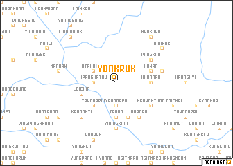
Yonkruk (Shan, Myanmar)Yonkruk is a town in the Shan region of Myanmar. An overview map of the region around Yonkruk is displayed below.
regional and 3d topo map of Yonkruk, Myanmar ::
Yonkruk airports ::
The nearest airport is LSH - Lashio, located 125.6 km west of Yonkruk.
Other airports nearby include KET - Kengtung (214.2 km south), Nearby towns ::
Yawngpra (3.7km south) //
Hpangka-tau (3.4km west) //
Htak-hting (3.9km north west) //
Yawngprim (5.0km south west) //
Hkannan (5.1km east) //
Ta-pon (5.6km south) //
Yawngnawng (5.8km south) //
Loi-chin (5.4km west) //
Hkwan (5.4km east) //
Hkawnhtung (6.3km south east) //
Yonkyo (6.3km south east) //
Hpanpo (6.5km south east) //
Pangkao (6.3km north east) //
Yawngk'rai (7.4km south) //
Awsai (7.1km east) //
Kawngkyi (7.6km south west) //
Man Huk (8.8km north east) //
Hpaknam (9.0km north east) //
Loi-ho-nguk (10.1km north west) //
[all distances 'as the bird flies' and approximate] 
Disclaimer :: Information on this page comes without warranty of any kind |
||
|
Where is Yonkruk? Elevation and coordinates ::
Latitude (lat): 23°8'0"N Longitude (lon): 98°58'0"E
Elevation (approx.): 1045m (map arrows pan, magnifying glasses zoom) |
||
|
Visiting Yonkruk? Hotel/Accommodation ::
Book a hotel in Yonkruk Travel Guide ::
Buy a travel guide for Myanmar rental cars ::
car rental offers GPS waypoint ::
download a GPX waypoint (PoI) of Yonkruk for your GPS receiver
|
||