|
search place name
|
||
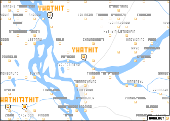
Ywathit (Myanmar)Ywathit is a town in Myanmar. An overview map of the region around Ywathit is displayed below.
regional and 3d topo map of Ywathit, Myanmar ::
Ywathit airports ::
The nearest airport is MDL - Mandalay Intl, located 173.7 km north east of Ywathit.
Other airports nearby include KYP - Kyaukpyu (185.7 km south west), HEH - Heho (200.6 km east), Nearby towns ::
Gyokpin (1.7km east) //
Thonzechauk (2.5km south east) //
Payagon (3.5km west) //
Obo (3.5km west) //
Pinwa (3.9km north west) //
Chaungmagyi (4.1km north east) //
Nyaungbintha (3.9km south west) //
Twingon (4.1km south east) //
Yenangyaung (5.6km south) //
Paunggadaw (5.8km south) //
Obozu (5.8km south) //
Sale (6.4km north west) //
Natkan-U (6.4km south east) //
Thitpyubin (6.4km south east) //
Thittabwe (7.4km south) //
Nyaungzaukchaung (7.2km east) //
Kyemyin (7.6km north east) //
Myezun (8.2km north east) //
Kyaukye (10.2km north west) //
Uyin (10.2km north east) //
Kyaungyadaw (10.2km north east) //
Thangaing (10.2km south west) //
[all distances 'as the bird flies' and approximate] 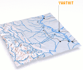 Places with similar names to Ywathit, Myanmar ::
Disclaimer :: Information on this page comes without warranty of any kind |
||
|
Where is Ywathit? Elevation and coordinates ::
Latitude (lat): 20°31'0"N Longitude (lon): 94°53'0"E
Elevation (approx.): 66m (map arrows pan, magnifying glasses zoom) |
||
|
Visiting Ywathit? Hotel/Accommodation ::
Book a hotel in Ywathit Travel Guide ::
Buy a travel guide for Myanmar rental cars ::
car rental offers GPS waypoint ::
download a GPX waypoint (PoI) of Ywathit for your GPS receiver
|
||