|
search place name
|
||
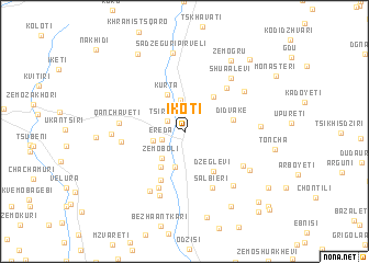
Ikoti (Abashis Raioni, Georgia)Ikoti is a town in the Abashis Raioni region of Georgia. An overview map of the region around Ikoti is displayed below.
regional and 3d topo map of Ikoti, Georgia ::
Nearby towns ::
Tsirkoli (1.7km north west) //
Ereda (1.9km south west) //
Korint'a (3.2km north) //
Bazuani (2.5km west) //
Zemo-Boli (3.2km south west) //
Akhalgori (3.7km south) //
K'urt'a (4.0km north) //
Morbedaani (4.0km south west) //
Kharkelani (4.1km north east) //
Dzeglevi (4.5km south east) //
Didvake (3.8km east) //
Garubani (5.2km south) //
Alevi (5.5km north east) //
Kvemo-Boli (6.1km south) //
Salbieri (6.1km south) //
Gekhavi (4.9km west) //
Qanch'avet'i (5.1km west) //
Chorchani (5.5km south east) //
Akhaldaba (6.7km south) //
Vashlovani (6.5km south west) //
Shua-Alevi (6.4km north east) //
Kvemo-Alevi (6.4km north east) //
Gudatsveri (6.1km north east) //
Dzveli Burghuli (6.6km south east) //
Gelauri (5.5km west) //
Delkani (6.2km south east) //
Dzhvarisubani (5.8km east) //
Sadzeguri Pirveli (8.1km north) //
Zemo-Gru (8.0km north east) //
[all distances 'as the bird flies' and approximate]  Places with similar names to Ikoti, Georgia ::
Disclaimer :: Information on this page comes without warranty of any kind |
||
|
Where is Ikoti? Elevation and coordinates ::
Latitude (lat): 42°9'5"N Longitude (lon): 44°29'28"E
Elevation (approx.): 922m (map arrows pan, magnifying glasses zoom) |
||
|
Visiting Ikoti? Hotel/Accommodation ::
Book a hotel in Ikoti Travel Guide ::
Buy a travel guide for Georgia rental cars ::
car rental offers GPS waypoint ::
download a GPX waypoint (PoI) of Ikoti for your GPS receiver
|
||