|
search place name
|
||
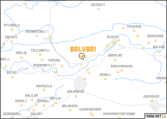
Balvarı (Sabirabad, Azerbaijan)Balvarı is a town in the Sabirabad region of Azerbaijan. An overview map of the region around Balvarı is displayed below.
regional and 3d topo map of Balvarı, Azerbaijan ::
Balvarı airports ::
The nearest airport is BAK - Baku Heydar Aliyev, located 141.2 km east of Balvarı.
Nearby towns ::
Hǝsǝnli (0.8km north east) //
Cavad (1.2km south west) //
Kürkǝndi (2.2km south) //
Sukovushan (3.1km south) //
Sabirabad (4.3km south) //
Əlicanlı (4.1km west) //
Surra (5.1km north east) //
Əsǝdli (5.7km south east) //
Türkǝdi (5.2km west) //
Maramly (5.5km south west) //
Qaralar (5.4km east) //
Axısxa (6.5km north east) //
Şıxlar (6.5km north east) //
Mǝmişlǝr (6.5km south east) //
Qalağayın (8.3km south) //
Şaumyanovka (6.9km east) //
Kichik Kovlyar (7.4km north east) //
Zǝngǝnǝ (7.7km north west) //
Novruzlu (9.6km south west) //
Qovlar (9.8km north east) //
[all distances 'as the bird flies' and approximate]  Places with similar names to Balvarı, Azerbaijan ::
Disclaimer :: Information on this page comes without warranty of any kind |
||
|
Where is Balvarı? Elevation and coordinates ::
Latitude (lat): 40°3'6"N Longitude (lon): 48°28'40"E
Elevation (approx.): -14m (map arrows pan, magnifying glasses zoom) |
||
|
Visiting Balvarı? Hotel/Accommodation ::
Book a hotel in Balvarı Travel Guide ::
Buy a travel guide for Azerbaijan rental cars ::
car rental offers GPS waypoint ::
download a GPX waypoint (PoI) of Balvarı for your GPS receiver
|
||