|
search place name
|
||
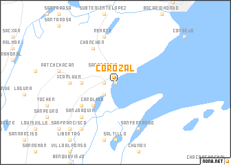
Corozal (Corozal, Belize)Corozal is a town in the Corozal region of Belize. An overview map of the region around Corozal is displayed below.
regional and 3d topo map of Corozal, Belize ::
Corozal airports ::
The nearest airport is CTM - Chetumal Intl, located 14.7 km north east of Corozal.
Other airports nearby include BZE - Belize City Philip S W Goldson Intl (93.8 km south), Nearby towns ::
Santa Rita (0.0km north) //
Paraiso (1.9km north) //
San Andres (1.8km west) //
Ranchito (2.6km south west) //
San Antonio (2.6km north west) //
Carolina (5.1km south west) //
Xaibe (5.3km west) //
Tacistal (5.3km west) //
Calcutta (6.4km south west) //
Chan Chen (6.6km north west) //
Xcanluum (7.0km west) //
Remate (7.6km north) //
San Joaquin (7.7km south west) //
America (7.7km south west) //
San Fernando (8.2km south east) //
Aventura (9.1km south west) //
Puebla Nueva (9.1km south west) //
San Francisco (10.2km south west) //
[all distances 'as the bird flies' and approximate] 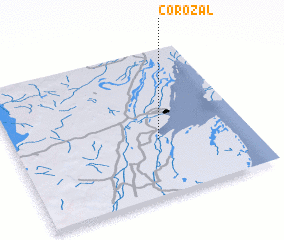 Places with similar names to Corozal, Belize ::
Disclaimer :: Information on this page comes without warranty of any kind |
||
|
Where is Corozal? Elevation and coordinates ::
Latitude (lat): 18°23'0"N Longitude (lon): 88°23'0"W
Elevation (approx.): -32768m (map arrows pan, magnifying glasses zoom) |
||
|
Visiting Corozal? Hotel/Accommodation ::
Book a hotel in Corozal Travel Guide ::
Buy a travel guide for Belize rental cars ::
car rental offers GPS waypoint ::
download a GPX waypoint (PoI) of Corozal for your GPS receiver
|
||