|
search place name
|
||
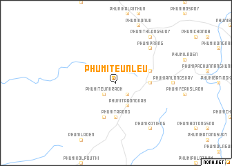
Phumĭ Teun Leu (Rôtânăh Kiri, Cambodia)Phumĭ Teun Leu is a town in the Rôtânăh Kiri region of Cambodia. An overview map of the region around Phumĭ Teun Leu is displayed below.
regional and 3d topo map of Phumĭ Teun Leu, Cambodia ::
Phumĭ Teun Leu airports ::
The nearest airport is PKZ - Pakse, located 198.4 km north west of Phumĭ Teun Leu.
Nearby towns ::
Phumĭ Teun Kraôm (2.6km south west) //
Phumĭ Labăng Siĕk (2.6km south east) //
Phumĭ Cha Ŭng Kândal (2.6km north east) //
Phumĭ Ta Aông Kăb (4.1km south east) //
Bông Lông (5.4km east) //
Phumĭ Ta Aông (5.6km south) //
Phumĭ Ka Aôl (5.8km south) //
Phumĭ Pôy (5.7km east) //
Phumĭ Prang (7.8km north east) //
Phumĭ Katiĕng (9.2km south east) //
Phumĭ Thlâng Svay (9.2km north east) //
[all distances 'as the bird flies' and approximate]  Places with similar names to Phumĭ Teun Leu, Cambodia ::
// Phumĭ Don L'â (KH)
// Phumĭ Don Lei (KH)
// Phumĭ Don Lôy (KH)
// Phumĭ Ta Năl (KH)
// Phumĭ Ta Nél (KH)
// Phumĭ Tônlé (KH)
// Phumĭ Tônléa (KH)
Disclaimer :: Information on this page comes without warranty of any kind |
||
|
Where is Phumĭ Teun Leu? Elevation and coordinates ::
Latitude (lat): 13°44'0"N Longitude (lon): 106°56'0"E
Elevation (approx.): 274m (map arrows pan, magnifying glasses zoom) |
||
|
Visiting Phumĭ Teun Leu? Hotel/Accommodation ::
Book a hotel in Phumĭ Teun Leu Travel Guide ::
Buy a travel guide for Cambodia rental cars ::
car rental offers GPS waypoint ::
download a GPX waypoint (PoI) of Phumĭ Teun Leu for your GPS receiver
|
||