|
search place name
|
||
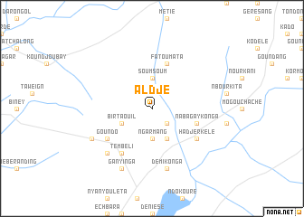
Aldjé (Ouaddaï, Chad)Aldjé is a town in the Ouaddaï region of Chad. An overview map of the region around Aldjé is displayed below.
regional and 3d topo map of Aldjé, Chad ::
Aldjé airports ::
The nearest airport is AEH - Abeche, located 138.5 km north west of Aldjé.
Nearby towns ::
Koulé (2.6km south east) //
Soumsoum (3.7km north) //
Ngarmang (3.7km south) //
Bir Taouil (4.1km south west) //
Koulé (4.1km south east) //
Fatoumata (5.8km north) //
Nabagay Konga (5.7km east) //
Tembéli (6.6km south west) //
Hadjer Kélé (6.6km south east) //
Goundo (6.6km south west) //
Démi Konga (7.6km south) //
Hilléket (7.8km south west) //
Bir Salé (8.1km south west) //
Ganyinga (8.2km south west) //
[all distances 'as the bird flies' and approximate]  Places with similar names to Aldjé, Chad ::
// Altja (EE)
// Aldige (ES)
// Alitaje (ES)
// Aladji (CF)
// Ali Ouidja (CF)
// Aladje (NG)
// Alate Iju (NG)
// Al ‘Atāʼij (IQ)
// Alédji (TG)
// Aalidji (SY)
Disclaimer :: Information on this page comes without warranty of any kind |
||
|
Where is Aldjé? Elevation and coordinates ::
Latitude (lat): 13°7'0"N Longitude (lon): 21°53'0"E
Elevation (approx.): 719m (map arrows pan, magnifying glasses zoom) |
||
|
Visiting Aldjé? Hotel/Accommodation ::
Book a hotel in Aldjé Travel Guide ::
Buy a travel guide for Chad rental cars ::
car rental offers GPS waypoint ::
download a GPX waypoint (PoI) of Aldjé for your GPS receiver
|
||