|
search place name
|
||
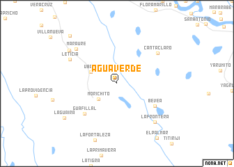
Agua Verde (Departamento de Casanare, Colombia)Agua Verde is a town in the Departamento de Casanare region of Colombia. An overview map of the region around Agua Verde is displayed below.
regional and 3d topo map of Agua Verde, Colombia ::
Agua Verde airports ::
The nearest airport is VVC - Villavicencio Vanguardia, located 138.5 km south west of Agua Verde.
Other airports nearby include BOG - Bogota Eldorado Intl (182.8 km west), TME - Tame (207.0 km north east), Nearby towns ::
Morichito (3.8km south west) //
Ubalá (4.6km north west) //
Bevea (7.1km south east) //
Guafillal (7.1km south west) //
Canta Claro (8.2km north east) //
Leticia (8.4km north west) //
Maraure (8.5km north west) //
La Frontera (8.7km south east) //
El Cairo (9.3km north west) //
La Guaira (10.0km south west) //
Berley (10.7km north west) //
El Palmar (10.9km south east) //
[all distances 'as the bird flies' and approximate] 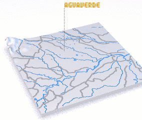 Places with similar names to Agua Verde, Colombia ::
// Ākhvord (IR)
// Agua Verde (CO)
// Agua Fuerte (SV)
// Agua Verde (MX)
// Agua Verde (MX)
// Agua Verde (MX)
// Agua Verde (MX)
// Agua Verde (MX)
// Agua Verde (MX)
// Agua Verde (MX)
Disclaimer :: Information on this page comes without warranty of any kind |
||
|
Where is Agua Verde? Elevation and coordinates ::
Latitude (lat): 4°43'54"N Longitude (lon): 72°29'57"W
Elevation (approx.): 189m (map arrows pan, magnifying glasses zoom) |
||
|
Visiting Agua Verde? Hotel/Accommodation ::
Book a hotel in Agua Verde Travel Guide ::
Buy a travel guide for Colombia rental cars ::
car rental offers GPS waypoint ::
download a GPX waypoint (PoI) of Agua Verde for your GPS receiver
|
||