|
search place name
|
||
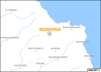
Agua Verde (Baja California Sur, Mexico)Agua Verde is a town in the Baja California Sur region of Mexico. An overview map of the region around Agua Verde is displayed below.
regional and 3d topo map of Agua Verde, Mexico ::
Agua Verde airports ::
The nearest airport is LTO - Loreto Intl, located 60.1 km north of Agua Verde.
Other airports nearby include LAP - La Paz General Manuel Marquez De Leon Intl (174.6 km south east), CEN - Ciudad Obregon Intl (248.1 km north east), Nearby towns ::
San Isidro (5.8km south) //
Santo Tomasito (7.5km south west) //
Puerto Agua Verde (7.5km east) //
San José de la Noria (9.1km south) //
[all distances 'as the bird flies' and approximate] 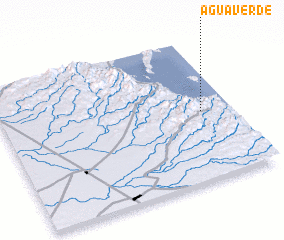 Places with similar names to Agua Verde, Mexico ::
// Ākhvord (IR)
// Agua Verde (CO)
// Agua Verde (CO)
// Agua Fuerte (SV)
// Agua Verde (MX)
// Agua Verde (MX)
// Agua Verde (MX)
// Agua Verde (MX)
// Agua Verde (MX)
// Agua Verde (MX)
Disclaimer :: Information on this page comes without warranty of any kind |
||
|
Where is Agua Verde? Elevation and coordinates ::
Latitude (lat): 25°29'0"N Longitude (lon): 111°8'0"W
Elevation (approx.): 329m (map arrows pan, magnifying glasses zoom) |
||
|
Visiting Agua Verde? Hotel/Accommodation ::
Book a hotel in Agua Verde Travel Guide ::
Buy a travel guide for Mexico rental cars ::
car rental offers GPS waypoint ::
download a GPX waypoint (PoI) of Agua Verde for your GPS receiver
|
||