|
search place name
|
||
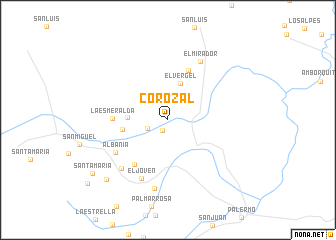
Corozal (Huila, Colombia)Corozal is a town in the Huila region of Colombia. An overview map of the region around Corozal is displayed below.
regional and 3d topo map of Corozal, Colombia ::
Corozal airports ::
The nearest airport is NVA - Neiva Benito Salas, located 24.6 km east of Corozal.
Other airports nearby include CLO - Cali Alfonso Bonilla Aragon Intl (114.4 km north west), SVI - San Vincente De Caguan Eduardo Falla Solano (124.3 km south east), PPN - Popayan Guillermo Leon Valencia (135.6 km south west), ULQ - Tulua Farfan (145.7 km north west), Nearby towns ::
Berlín (1.3km south west) //
El Jordán (2.4km west) //
El Vergel (4.3km north) //
El Encanto (4.5km west) //
Porvenir (5.2km west) //
La Cima (6.0km north) //
Patio Bonito (6.2km south west) //
La Esmeralda (6.2km west) //
Albania (6.9km south west) //
El Joven (7.2km south west) //
El Mirador (7.4km north east) //
Primavera (7.5km south west) //
San José (7.8km south) //
Altamira (9.6km south west) //
Santa María (10.3km south west) //
[all distances 'as the bird flies' and approximate]  Places with similar names to Corozal, Colombia ::
Disclaimer :: Information on this page comes without warranty of any kind |
||
|
Where is Corozal? Elevation and coordinates ::
Latitude (lat): 2°59'22"N Longitude (lon): 75°30'42"W
Elevation (approx.): 1404m (map arrows pan, magnifying glasses zoom) |
||
|
Visiting Corozal? Hotel/Accommodation ::
Book a hotel in Corozal Travel Guide ::
Buy a travel guide for Colombia rental cars ::
car rental offers GPS waypoint ::
download a GPX waypoint (PoI) of Corozal for your GPS receiver
|
||