|
search place name
|
||
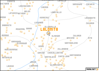
La Lomita (Huila, Colombia)La Lomita is a town in the Huila region of Colombia. An overview map of the region around La Lomita is displayed below.
regional and 3d topo map of La Lomita, Colombia ::
La Lomita airports ::
The nearest airport is FLA - Florencia Gustavo Artunduaga Paredes, located 75.1 km south of La Lomita.
Other airports nearby include NVA - Neiva Benito Salas (83.9 km north east), SVI - San Vincente De Caguan Eduardo Falla Solano (95.9 km east), PPN - Popayan Guillermo Leon Valencia (111.8 km west), CLO - Cali Alfonso Bonilla Aragon Intl (164.6 km north west), Nearby towns ::
Jagualito (1.2km north west) //
La Primavera (1.3km south east) //
La Cabrera (2.0km west) //
San Pedro (2.4km south) //
El Ladrillo (2.4km north) //
La Vega (2.5km south west) //
El Mesón (2.6km south east) //
San Alfonso (2.6km south east) //
Santa Rita (3.1km west) //
Potrerillo (3.2km north west) //
Los Jazmines (3.3km south) //
Terremoto (3.4km south west) //
Las Brisas (3.6km south) //
La Argentina (3.9km south west) //
Milán (4.3km south) //
El Balseadero (4.3km south west) //
Las Palmas (4.4km south) //
Santa Rosa (4.7km south) //
San José de Belén (4.9km west) //
Sartenejo (5.1km south) //
La Trina (5.2km north west) //
Manita (5.4km south) //
La Turbia (5.7km north west) //
Cascadalito (5.8km north east) //
Minas (5.9km south west) //
La Calderón (6.1km north east) //
Ríoloro (6.1km north) //
Veracruz (6.2km north) //
Tierra Grata (6.3km west) //
[all distances 'as the bird flies' and approximate]  Places with similar names to La Lomita, Colombia ::
// La Lomita (PA)
// La Alameda (ES)
// La Alameda (ES)
// La Alameda (ES)
// La Alameda (ES)
// La Alameda (ES)
// La Olmeda (ES)
// La Olmeda (ES)
// La Alameda (CO)
// La Lomita (CO)
Disclaimer :: Information on this page comes without warranty of any kind |
||
|
Where is La Lomita? Elevation and coordinates ::
Latitude (lat): 2°15'58"N Longitude (lon): 75°37'17"W
Elevation (approx.): 815m (map arrows pan, magnifying glasses zoom) |
||
|
Visiting La Lomita? Hotel/Accommodation ::
Book a hotel in La Lomita Travel Guide ::
Buy a travel guide for Colombia rental cars ::
car rental offers GPS waypoint ::
download a GPX waypoint (PoI) of La Lomita for your GPS receiver
|
||