|
search place name
|
||
Shifuma (Congo, Democratic Republic of the)Shifuma is a town in Congo, Democratic Republic of the. An overview map of the region around Shifuma is displayed below.
regional and 3d topo map of Shifuma, Congo, Democratic Republic of the ::

Shifuma airports ::
The nearest airport is BKY - Bukavu/kavumu Bukavu Kavumu, located 10.4 km north of Shifuma.
Other airports nearby include KME - Kamembe (10.8 km south east), GOM - Goma (92.4 km north east), GYI - Gisenyi (92.9 km north east), BJM - Bujumbura Intl (115.5 km south east), Nearby towns ::
Kidumbi (3.7km west) //
Mushuva (4.1km north east) //
Kanonzi (5.2km north) //
Hongo (5.6km south) //
Mudaka (5.9km west) //
Kabare (7.7km south) //
Miti (7.9km north west) //
Luamisole (8.2km north) //
Mulungu (9.1km north west) //
Muhari (10.5km south east) //
Tshibinda (11.8km north west) //
[all distances 'as the bird flies' and approximate] 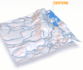 Places with similar names to Shifuma, Congo, Democratic Republic of the ::
// Shavuma (CD)
// Siafoumou (CG)
// Chefamuai (TP)
// Chavuma (ZM)
// Chivimba (ZM)
// Chivumba (ZM)
// Chefe Aiamo (MZ)
// Chefe Mauai (MZ)
// Chefe Meia (MZ)
// Chefe Moeia (MZ)
Disclaimer :: Information on this page comes without warranty of any kind |
||
|
Where is Shifuma? Elevation and coordinates ::
Latitude (lat): 2°24'0"S Longitude (lon): 28°50'0"E
Elevation (approx.): 1622m (map arrows pan, magnifying glasses zoom) |
||
|
Visiting Shifuma? Hotel/Accommodation ::
Book a hotel in Shifuma Travel Guide ::
rental cars ::
car rental offers GPS waypoint ::
download a GPX waypoint (PoI) of Shifuma for your GPS receiver
|
||