|
search place name
|
||
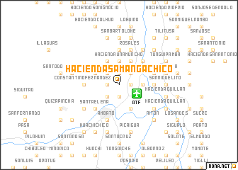
Hacienda Samanga Chico (Tungurahua, Ecuador)Hacienda Samanga Chico is a town in the Tungurahua region of Ecuador. An overview map of the region around Hacienda Samanga Chico is displayed below.
regional and 3d topo map of Hacienda Samanga Chico, Ecuador ::
Hacienda Samanga Chico airports ::
The nearest airport is ATF - Ambato Chachoan, located 3.1 km south east of Hacienda Samanga Chico.
Other airports nearby include UIO - Quito Mariscal Sucre Intl (117.7 km north), XMS - Macas Coronel E Carvajal (132.7 km south east), GYE - Guayaquil Jose Joaquin De Olmedo Intl (177.8 km south west), CUE - Cuenca Mariscal Lamar (191.6 km south), Nearby towns ::
Hacienda Chasinata (1.9km east) //
Hacienda Pisque (1.9km east) //
Hacienda Samanga de Sevilla (1.9km north) //
Atocha (1.9km south) //
Hacienda Patulata (1.9km north) //
Hacienda Maiañon (1.9km west) //
Hacienda Sarces (1.9km west) //
Hacienda Naranjo (2.6km north east) //
Puerto Arturo (2.6km north east) //
Hacienda de Rosa Barona (2.6km north east) //
Augusto N. Martínez (2.6km south west) //
Atahualpa (2.6km south west) //
Hacienda Villacres (2.6km north west) //
Hacienda de Jáuregui (3.7km east) //
Hacienda de Tinajero (3.7km north) //
Hacienda Unamuncho (3.7km north) //
Izamba (4.1km south east) //
Hacienda Barberis (4.1km north east) //
Hacienda López (4.1km north west) //
Hacienda Chaupi (4.1km north west) //
Hacienda Muñoz (4.1km north west) //
Hacienda Pondoa (4.1km north west) //
Hacienda Chural (5.2km north east) //
Santa Elena (5.2km south west) //
Ficoa (5.2km south west) //
Hacienda Panguigua (5.6km east) //
Hacienda San Pablo (5.6km north) //
Hacienda El Conde (5.6km north) //
Constantino Fernández (5.6km west) //
[all distances 'as the bird flies' and approximate]  Places with similar names to Hacienda Samanga Chico, Ecuador :: Disclaimer :: Information on this page comes without warranty of any kind |
||
|
Where is Hacienda Samanga Chico? Elevation and coordinates ::
Latitude (lat): 1°12'0"S Longitude (lon): 78°36'0"W
Elevation (approx.): 2672m (map arrows pan, magnifying glasses zoom) |
||
|
Visiting Hacienda Samanga Chico? Hotel/Accommodation ::
Book a hotel in Hacienda Samanga Chico Travel Guide ::
Buy a travel guide for Ecuador rental cars ::
car rental offers GPS waypoint ::
download a GPX waypoint (PoI) of Hacienda Samanga Chico for your GPS receiver
|
||