|
search place name
|
||
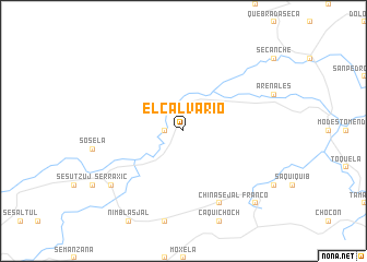
El Calvario (Izabal, Guatemala)El Calvario is a town in the Izabal region of Guatemala. An overview map of the region around El Calvario is displayed below.
regional and 3d topo map of El Calvario, Guatemala ::
El Calvario airports ::
The nearest airport is CBV - Coban, located 120.6 km west of El Calvario.
Other airports nearby include SAP - San Pedro Sula La Mesa Intl (161.9 km east), GUA - Guatemala City La Aurora (190.4 km south west), TEA - Tela (202.9 km east), BZE - Belize City Philip S W Goldson Intl (215.2 km north east), Nearby towns ::
Gracias a Dios (1.8km west) //
Chinasejal (8.2km south east) //
Serraxic (9.0km south west) //
Franco (10.3km south east) //
[all distances 'as the bird flies' and approximate] 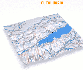 Places with similar names to El Calvario, Guatemala ::
// El Calvario (PA)
// El Calvario (PA)
// El Calvario (PA)
// El Calvario (CU)
// El Calvario (CU)
// El Calvario (ES)
// El Calvario (CL)
// El Calvario (CO)
// El Calvario (CO)
// El Calvario (CO)
Disclaimer :: Information on this page comes without warranty of any kind |
||
|
Where is El Calvario? Elevation and coordinates ::
Latitude (lat): 15°53'0"N Longitude (lon): 89°22'0"W
Elevation (approx.): 97m (map arrows pan, magnifying glasses zoom) |
||
|
Visiting El Calvario? Hotel/Accommodation ::
Book a hotel in El Calvario Travel Guide ::
Buy a travel guide for Guatemala rental cars ::
car rental offers GPS waypoint ::
download a GPX waypoint (PoI) of El Calvario for your GPS receiver
|
||