|
search place name
|
||
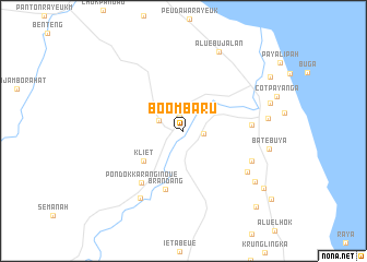
Boombaru (Aceh, Indonesia)Boombaru is a town in the Aceh region of Indonesia. An overview map of the region around Boombaru is displayed below.
regional and 3d topo map of Boombaru, Indonesia ::
Boombaru airports ::
The nearest airport is MES - Medan Polonia, located 166.2 km south east of Boombaru.
Other airports nearby include LGK - Pulau Langkawi Intl (271.2 km north east), Nearby towns ::
Blangbarom (1.5km north) //
Payakalui (2.1km east) //
Rantaupanjang (2.7km north west) //
Kliet (5.1km south west) //
Brandang (6.3km south) //
Pondokkaranginoue (6.8km south west) //
Peureulak (7.0km east) //
Damatutong (7.6km south east) //
Jeungki (7.8km south east) //
Gedungjaneng (8.1km south west) //
Peureulak (8.7km east) //
Aluebujalan (8.9km north east) //
Kruetlintang (8.9km south east) //
Batebuya (8.9km east) //
Cotkeli (9.3km east) //
Sematangkedai (10.0km south east) //
Blangbalok (10.4km north east) //
Seneboklapang (10.7km south east) //
[all distances 'as the bird flies' and approximate] 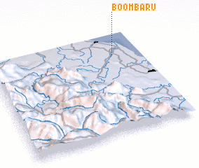 Places with similar names to Boombaru, Indonesia ::
Disclaimer :: Information on this page comes without warranty of any kind |
||
|
Where is Boombaru? Elevation and coordinates ::
Latitude (lat): 4°47'40"N Longitude (lon): 97°49'13"E
Elevation (approx.): 18m (map arrows pan, magnifying glasses zoom) |
||
|
Visiting Boombaru? Hotel/Accommodation ::
Book a hotel in Boombaru Travel Guide ::
Buy a travel guide for Indonesia rental cars ::
car rental offers GPS waypoint ::
download a GPX waypoint (PoI) of Boombaru for your GPS receiver
|
||