|
search place name
|
||
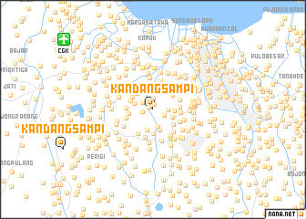
Kandangsampi (Indonesia)Kandangsampi is a town in Indonesia. An overview map of the region around Kandangsampi is displayed below.
regional and 3d topo map of Kandangsampi, Indonesia ::
Kandangsampi airports ::
The nearest airport is CGK - Jakarta Soekarno Hatta Intl, located 13.8 km north west of Kandangsampi.
Nearby towns ::
Srengseng (0.6km north west) //
Pejuangan (0.6km north west) //
Rawatigasuku (0.6km north) //
Meruya-udik (1.3km west) //
Pesanggralian (1.4km north) //
Kruntagan (1.5km south east) //
Kembangkerep (1.5km north west) //
Klapadua (1.8km east) //
Pengumbert (2.2km south) //
Penggilingan (2.4km west) //
Bugis (2.6km north) //
Kedawung (2.6km south) //
Duri (2.6km north east) //
Pinyuair (2.6km north) //
Suteng (2.6km east) //
Sukabumi (2.6km east) //
Baru (2.7km south) //
Kedaya (2.7km north) //
Kembangan (2.8km north west) //
Petukangan (2.9km south) //
Cantiga (2.9km north west) //
Jerukmanis (2.9km west) //
Pekayon (3.0km west) //
Laji (3.0km north east) //
Pasarminggu (3.1km north west) //
Tanahkoja (3.1km south east) //
Bulak (3.2km north) //
Palmerah (3.2km east) //
Meruya-hilir (3.3km west) //
[all distances 'as the bird flies' and approximate]  Places with similar names to Kandangsampi, Indonesia ::
// Kandangsampi (ID)
// Kandangsampi (ID)
Disclaimer :: Information on this page comes without warranty of any kind |
||
|
Where is Kandangsampi? Elevation and coordinates ::
Latitude (lat): 6°12'10"S Longitude (lon): 106°45'15"E
Elevation (approx.): 14m (map arrows pan, magnifying glasses zoom) |
||
|
Visiting Kandangsampi? Hotel/Accommodation ::
Book a hotel in Kandangsampi Travel Guide ::
Buy a travel guide for Indonesia rental cars ::
car rental offers GPS waypoint ::
download a GPX waypoint (PoI) of Kandangsampi for your GPS receiver
|
||