|
search place name
|
||
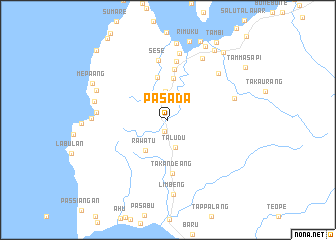
Pasada (Sulawesi Selatan, Indonesia)Pasada is a town in the Sulawesi Selatan region of Indonesia. An overview map of the region around Pasada is displayed below.
regional and 3d topo map of Pasada, Indonesia ::
Pasada airports ::
The nearest airport is PLW - Palu Mutiara, located 234.3 km north east of Pasada.
Other airports nearby include PSJ - Poso Kasiguncu (249.0 km north east), Nearby towns ::
Adiadi (1.3km south) //
Dolangan (2.0km north) //
Botteng (3.2km north) //
Taludu (3.2km south) //
Rawatu (4.2km south west) //
Patidi (4.7km north) //
Salupalli (4.9km north) //
Saluppangi (5.7km north) //
Takandeang (6.0km south) //
Simbuang (6.6km north) //
Sese (6.7km north) //
Karema (7.6km north) //
Kelapatujuh (7.7km north east) //
Salulullung (7.8km east) //
Padangbaka (7.8km north east) //
Tamala (8.1km west) //
Limbeng (8.4km south) //
Ladoko (8.5km west) //
Lebani (8.5km west) //
Simboro (8.6km north) //
Takke (8.6km north west) //
Rimuku (9.1km north) //
Mamuju (9.2km north east) //
Danga (9.3km north east) //
Mepaang (9.3km north west) //
Kasiwa (9.5km north east) //
Sangkurio (9.7km north east) //
Tambi (10.2km north east) //
Tammasapi (10.4km north east) //
[all distances 'as the bird flies' and approximate] 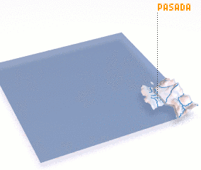 Places with similar names to Pasada, Indonesia ::
Disclaimer :: Information on this page comes without warranty of any kind |
||
|
Where is Pasada? Elevation and coordinates ::
Latitude (lat): 2°45'10"S Longitude (lon): 118°51'21"E
Elevation (approx.): 197m (map arrows pan, magnifying glasses zoom) |
||
|
Visiting Pasada? Hotel/Accommodation ::
Book a hotel in Pasada Travel Guide ::
Buy a travel guide for Indonesia rental cars ::
car rental offers GPS waypoint ::
download a GPX waypoint (PoI) of Pasada for your GPS receiver
|
||