|
search place name
|
||
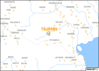
Tojambu (Indonesia)Tojambu is a town in Indonesia. An overview map of the region around Tojambu is displayed below.
regional and 3d topo map of Tojambu, Indonesia ::
Tojambu airports ::
The nearest airport is PSJ - Poso Kasiguncu, located 178.8 km north of Tojambu.
Nearby towns ::
Rindingalo (2.1km south west) //
Tetewasik (3.4km south east) //
Tobila (3.6km south) //
Barangmamase (4.1km north east) //
Padanglambe (4.1km east) //
Tarta (4.6km north east) //
Battang (4.9km south east) //
Kaluku (5.5km north east) //
Padanglipan (5.8km north east) //
Tumaraja (8.0km north east) //
Karetan (8.2km north east) //
Laleng-balandae (8.3km south east) //
Buntubuku (8.3km north east) //
Lekong (8.4km north east) //
Popabri (8.4km east) //
Bolukanna (8.6km north east) //
Maendopantilang (9.1km north east) //
Saragi (9.3km north east) //
Uraso (9.8km north east) //
Ilanbatu (11.4km north east) //
[all distances 'as the bird flies' and approximate] 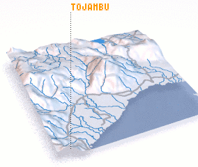 Places with similar names to Tojambu, Indonesia ::
Disclaimer :: Information on this page comes without warranty of any kind |
||
|
Where is Tojambu? Elevation and coordinates ::
Latitude (lat): 2°56'0"S Longitude (lon): 120°6'0"E
Elevation (approx.): 731m (map arrows pan, magnifying glasses zoom) |
||
|
Visiting Tojambu? Hotel/Accommodation ::
Book a hotel in Tojambu Travel Guide ::
Buy a travel guide for Indonesia rental cars ::
car rental offers GPS waypoint ::
download a GPX waypoint (PoI) of Tojambu for your GPS receiver
|
||