|
search place name
|
||
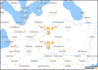
Lala (Ghana)Lala is a town in Ghana. An overview map of the region around Lala is displayed below.
regional and 3d topo map of Lala, Ghana ::
Lala airports ::
The nearest airport is LRL - Niatougou Niamtougou International, located 110.7 km south east of Lala.
Other airports nearby include TML - Tamale (142.1 km south west), Nearby towns ::
Wenchiki (1.3km north west) //
Nachikongo (1.9km north) //
Dambu (1.8km west) //
Sherabu (2.6km north east) //
Nachiko (2.6km north west) //
Diana (4.1km north east) //
Kpeidi (4.1km north east) //
Chere-Drakankanu (4.1km south east) //
Kablani (4.1km south east) //
Ando (4.1km north west) //
Beigbunde (4.1km north west) //
Kuanu-Nansoni (4.1km south west) //
Nachiem (4.1km south west) //
Nyamijawga (5.2km north east) //
Nawiogu (5.2km north west) //
Kunajigu (5.5km west) //
Lala (5.6km south) //
Jakpari (5.9km south) //
Kokpogele (5.8km west) //
Nyambande (6.6km south east) //
Tembuon (6.6km south west) //
Kpananbogu (7.4km north) //
Kpatani (7.6km north) //
Chere (7.5km east) //
Chantendi (7.5km east) //
Tukpandi (7.6km south) //
Timanga (7.5km west) //
Nazawni (7.6km south) //
Nawari (7.8km south east) //
[all distances 'as the bird flies' and approximate] 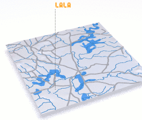 Places with similar names to Lala, Ghana ::
Disclaimer :: Information on this page comes without warranty of any kind |
||
|
Where is Lala? Elevation and coordinates ::
Latitude (lat): 10°16'0"N Longitude (lon): 0°13'0"W
Elevation (approx.): 155m (map arrows pan, magnifying glasses zoom) |
||
|
Visiting Lala? Hotel/Accommodation ::
Book a hotel in Lala Travel Guide ::
Buy a travel guide for Ghana rental cars ::
car rental offers GPS waypoint ::
download a GPX waypoint (PoI) of Lala for your GPS receiver
|
||