|
search place name
|
||
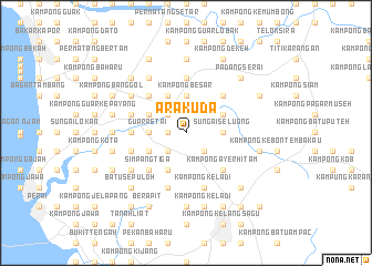
Ara Kuda (Pulau Pinang, Malaysia)Ara Kuda is a town in the Pulau Pinang region of Malaysia. An overview map of the region around Ara Kuda is displayed below.
regional and 3d topo map of Ara Kuda, Malaysia ::
Ara Kuda airports ::
The nearest airport is PEN - Penang Intl, located 31.5 km south west of Ara Kuda.
Other airports nearby include AOR - Alor Setar Sultan Abdul Halim (82.8 km north), IPH - Ipoh Sultan Azlan Shah (116.6 km south east), LGK - Pulau Langkawi Intl (130.7 km north west), PAN - Pattani (163.6 km north east), Nearby towns ::
Kampong Jarak (1.8km west) //
Lunas (2.6km south east) //
Lubok Batu (2.6km south west) //
Padang Chempedak (2.6km north west) //
Lubok Binjal (2.6km south west) //
Kampong Sungai Kulim (2.6km south west) //
Sungai Seluang (3.7km east) //
Kampong Besar (3.7km north) //
Guar Petai (3.7km west) //
Paya Telunjok (4.1km north east) //
Mengkuang Tandop (4.1km south west) //
Tasek Gelugur (4.1km north west) //
Kampong Mengkuang (4.1km south west) //
Padang Manora (4.1km north west) //
Kampong Pokok Tampang (4.1km north west) //
Kampong Ayer Hitam (5.2km south east) //
Kampong Permatang Tokdik (5.2km north east) //
Kampong Permatang Durian (5.2km north east) //
Kampong Nega Lilit (5.2km north east) //
Kampong Sungai Limau (5.2km south east) //
Kubang Ulu (5.2km south west) //
Mengkuang Titi (5.2km south west) //
Penanti (5.2km south west) //
Kampong Permatang Berangan (5.2km north west) //
Kampong Lahar Tembun (5.2km north west) //
Simpang Tiga (5.2km south west) //
Tok Jawa (5.5km west) //
Kampong Selamat (5.6km north) //
Kampong Keladi (5.9km south) //
[all distances 'as the bird flies' and approximate]  Places with similar names to Ara Kuda, Malaysia ::
Disclaimer :: Information on this page comes without warranty of any kind |
||
|
Where is Ara Kuda? Elevation and coordinates ::
Latitude (lat): 5°27'0"N Longitude (lon): 100°31'0"E
Elevation (approx.): 25m (map arrows pan, magnifying glasses zoom) |
||
|
Visiting Ara Kuda? Hotel/Accommodation ::
Book a hotel in Ara Kuda Travel Guide ::
Buy a travel guide for Malaysia rental cars ::
car rental offers GPS waypoint ::
download a GPX waypoint (PoI) of Ara Kuda for your GPS receiver
|
||