|
search place name
|
||
Kampong Masjid (Pulau Pinang, Malaysia)Kampong Masjid is a town in the Pulau Pinang region of Malaysia. An overview map of the region around Kampong Masjid is displayed below.
regional and 3d topo map of Kampong Masjid, Malaysia ::

Kampong Masjid airports ::
The nearest airport is PEN - Penang Intl, located 1.7 km north west of Kampong Masjid.
Other airports nearby include AOR - Alor Setar Sultan Abdul Halim (101.0 km north), IPH - Ipoh Sultan Azlan Shah (119.6 km south east), LGK - Pulau Langkawi Intl (131.0 km north west), HDY - Songkhla Hat Yai Intl (182.9 km north), Nearby towns ::
Bagan Batu Maung (0.0km north) //
Batu Maung (0.0km north) //
Permatang Damar Laut (0.0km north) //
Kampong Batu Maung (0.0km north) //
Kampong Telok Tempoyak Kechil (0.0km north) //
Kampong Permatang Masjid (1.8km west) //
Kampong Permatang Pak Ali Rahman (1.8km west) //
Kampong Permatang Damar Laut (1.8km west) //
Kampong Permatang Tepi Laut (1.8km west) //
Bayan Lepas (1.8km west) //
Permatang Bakar Kapor (1.8km west) //
Kampong Telok Tempoyak Besar (1.9km south) //
Kampong Sungai Tiram (1.9km north) //
Kampong Naran (1.9km north) //
Kampong Masjid (2.6km north west) //
Kampong Bukit (2.6km north west) //
Kampong Perlis (2.6km north west) //
Batu Jambul (3.0km south west) //
Kampong Permatang (3.7km west) //
Kampong Pengkalan (3.7km north) //
Kampong Gedong (3.7km north) //
Kampong Sungai Keluang (3.7km north) //
Nangka Mambong (3.7km north) //
Kampong Pulau (3.7km north) //
Kampong Seronok (4.1km north west) //
Kampong Sepuloh (4.1km north west) //
Kongsi Sepuloh (4.1km north west) //
Kampong Jawa (4.1km north east) //
Kampong Permatang Rumenia (4.1km north east) //
[all distances 'as the bird flies' and approximate] 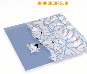 Places with similar names to Kampong Masjid, Malaysia ::
// Kampong Masjid (MY)
// Kampong Masjid (MY)
// Kampong Masjid (MY)
// Kampong Masjid (MY)
// Kampong Masjid (MY)
// Kampong Masjid (MY)
// Kampong Masjid (MY)
// Kampong Masjid (MY)
// Kampong Masjid (MY)
// Kampong Masjid (MY)
Disclaimer :: Information on this page comes without warranty of any kind |
||
|
Where is Kampong Masjid? Elevation and coordinates ::
Latitude (lat): 5°17'0"N Longitude (lon): 100°17'0"E
Elevation (approx.): 8m (map arrows pan, magnifying glasses zoom) |
||
|
Visiting Kampong Masjid? Hotel/Accommodation ::
Book a hotel in Kampong Masjid Travel Guide ::
Buy a travel guide for Malaysia rental cars ::
car rental offers GPS waypoint ::
download a GPX waypoint (PoI) of Kampong Masjid for your GPS receiver
|
||