|
search place name
|
||
Pokok Manggis (Pulau Pinang, Malaysia)Pokok Manggis is a town in the Pulau Pinang region of Malaysia. An overview map of the region around Pokok Manggis is displayed below.
regional and 3d topo map of Pokok Manggis, Malaysia ::

Pokok Manggis airports ::
The nearest airport is PEN - Penang Intl, located 10.2 km south east of Pokok Manggis.
Other airports nearby include AOR - Alor Setar Sultan Abdul Halim (93.2 km north), LGK - Pulau Langkawi Intl (119.4 km north west), IPH - Ipoh Sultan Azlan Shah (131.3 km south east), HDY - Songkhla Hat Yai Intl (174.3 km north), Nearby towns ::
Kampong Bagan Ayer Itam (0.0km north) //
Titi Perupok (0.0km north) //
Kampong Titi Tras (1.8km east) //
Kampong Sungai Rusa (1.9km north) //
Kampong Permatang Tengah (1.9km south) //
Kampong Paya Kongsi (1.9km south) //
Kampong Jalan Baharu (1.9km south) //
Kampong Permatang Pasir (1.8km west) //
Kuala Jalan Baharu (1.8km west) //
Ayer Puteh (2.6km south east) //
Kampong Titi Serong (2.6km south east) //
Balik Pulau (2.6km south east) //
Kampong Permatang Timbun (2.6km south east) //
Permatang Timbun (2.6km south east) //
Kampong Bukit Kechil (3.7km north) //
Kampong Pek Sin (3.7km north) //
Kampong Sungai Pinang (3.7km north) //
Sungai Pinang (3.7km north) //
Simpang Ampat (3.7km south) //
Kampong Paya (3.7km south) //
Kampong Shee Tan (3.7km south) //
Genting (3.7km south) //
Bagan Kuala Sungai Pinang (4.1km north west) //
Kampong Batu Puteh (4.1km north west) //
Kampong Setul (4.1km south east) //
Kampong Pondok Upeh (4.1km south east) //
Kampong Sungai Burong (4.1km south west) //
Kampong Enam (4.1km south west) //
Kampong Kafri (5.2km south east) //
[all distances 'as the bird flies' and approximate] 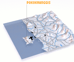 Places with similar names to Pokok Manggis, Malaysia :: Disclaimer :: Information on this page comes without warranty of any kind |
||
|
Where is Pokok Manggis? Elevation and coordinates ::
Latitude (lat): 5°22'0"N Longitude (lon): 100°13'0"E
Elevation (approx.): 9m (map arrows pan, magnifying glasses zoom) |
||
|
Visiting Pokok Manggis? Hotel/Accommodation ::
Book a hotel in Pokok Manggis Travel Guide ::
Buy a travel guide for Malaysia rental cars ::
car rental offers GPS waypoint ::
download a GPX waypoint (PoI) of Pokok Manggis for your GPS receiver
|
||