|
search place name
|
||
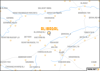
‘Alī Badal (Kordestān, Iran)‘Alī Badal is a town in the Kordestān region of Iran. An overview map of the region around ‘Alī Badal is displayed below.
regional and 3d topo map of ‘Alī Badal, Iran ::
‘Alī Badal airports ::
The nearest airport is SDG - Sanandaj, located 91.5 km south west of ‘Alī Badal.
Other airports nearby include KSH - Bakhtaran Shahid Ashrafi Esfahani (180.0 km south), Nearby towns ::
Alvand Qolī (3.0km west) //
Mokhvor (4.0km south) //
Qareh Bolāgh (4.0km south) //
Kheyrābād (3.5km south west) //
Khvoshāb (5.6km north) //
Ḩalvā'ī (5.8km south) //
Qameshlū (5.0km east) //
Takht-e Soflá (6.3km south east) //
Changīz Qal‘eh (7.6km south) //
Posht Darband (7.6km north) //
Qeyşeh (6.8km west) //
Ne‘matābād-e ‘Olyā (7.1km south west) //
Bījār (8.3km south east) //
Takht-e ‘Olyā (8.9km south east) //
[all distances 'as the bird flies' and approximate]  Places with similar names to ‘Alī Badal, Iran ::
// Al Baddālah (EG)
// Albuţele (RO)
// Alabaytal (RU)
// Alobaytal (TJ)
// Al ‘Abādlah (EG)
// ‘Alīābād-e A‘lā' (IR)
// ‘Alīābād-e Ālū (IR)
// Al Baţţāl (LB)
// ‘Alī ‘Abd Allāh (YE)
// Alabaytal (KZ)
Disclaimer :: Information on this page comes without warranty of any kind |
||
|
Where is ‘Alī Badal? Elevation and coordinates ::
Latitude (lat): 35°56'0"N Longitude (lon): 47°34'0"E
Elevation (approx.): 1886m (map arrows pan, magnifying glasses zoom) |
||
|
Visiting ‘Alī Badal? Hotel/Accommodation ::
Book a hotel in ‘Alī Badal Travel Guide ::
Buy a travel guide for Iran rental cars ::
car rental offers GPS waypoint ::
download a GPX waypoint (PoI) of ‘Alī Badal for your GPS receiver
|
||